Title
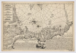
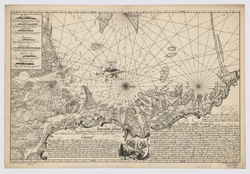
Nieuwe accurate passkaart voornamlijk, van het Helgeland, na de Elwe, Weeser, Eijder en Hewer ; met de droogtens en dieptens, reeven en sanden, streking en courssen : nae een regtwijsend compas
Creator / Contributor
Pingeling, T. A. (Thomas Albrecht), 1727-1803
Attribution
T.A. Pingeling Jun. sculp.
Date
1762 1762.
Place of Origin
Germany Hamburg :
Publisher
[Publisher not identified],
Extent
1 map ; 56 x 89 cm
Language
Dutch; Flemish
Genre
map cartographic image Early maps. Nautical chart. Early works to 1800 Maps
Digital Format
Images
Subjects
Nautical charts--Germany--North Sea Coast--Early works to 1800 Nautical charts--Germany--Helgoland Bight--Early works to 1800 Coasts--Germany--Helgoland Bight--Maps--Early works to 1800 North Sea Coast (Germany)--Maps--Early works to 1800 Helgoland Bight (Germany)--Maps--Early works to 1800
Notes
Depth shown by soundings. Also shows rhumb lines, sand bars and reefs.
Classification
G6082.C6 1762 .N5
Repository
Harvard Map Collection, Harvard University
Record ID
990142534720203941
Title
Nieuwe accurate passkaart voornamlijk, van het Helgeland, na de Elwe, Weeser, Eijder en Hewer ; met de droogtens en dieptens, reeven en sanden, streking en courssen : nae een regtwijsend compas
Creator / Contributor
Pingeling, T. A. (Thomas Albrecht), 1727-1803
Attribution
T.A. Pingeling Jun. sculp.
Date
1762 1762.
Place of Origin
Germany Hamburg :
Publisher
[Publisher not identified],
Extent
1 map ; 56 x 89 cm
Language
Dutch; Flemish
Genre
map cartographic image Early maps. Nautical chart. Early works to 1800 Maps
Digital Format
Images
Subjects
Nautical charts--Germany--North Sea Coast--Early works to 1800 Nautical charts--Germany--Helgoland Bight--Early works to 1800 Coasts--Germany--Helgoland Bight--Maps--Early works to 1800 North Sea Coast (Germany)--Maps--Early works to 1800 Helgoland Bight (Germany)--Maps--Early works to 1800
Notes
Depth shown by soundings. Also shows rhumb lines, sand bars and reefs.
Classification
G6082.C6 1762 .N5
Repository
Harvard Map Collection, Harvard University
Record ID
990142534720203941