-
Title
-
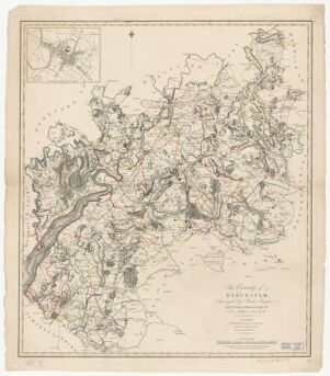
The county of Glocester ; Surveyed by Isaac Taylor, and planned from a scale of two miles to one inch
-
- Taylor, Isaac, 1730-1807, creator
Faden, William, 1749-1836
-
- Feby. 1st. 1800
1800
-
- England
London
-
- Published by W. Faden, Geogr. to the King ... Charing Cross
-
- 1 map : hand col. ; 65 x 57 cm.
-
- English
-
- map
Road maps.
Maps
-
- Images
-
- Gloucestershire (England)--Maps
Gloucestershire (England)--Administrative and political divisions--Maps
Gloucester (England)--Maps
-
- Actual scale varies slightly from stated 2 miles to 1 inch.
Inset map: City of Glocester.
Also available online.
-
- Harvard Map Collection digital maps
-
- Harvard Map Collection, Harvard University
-
- 990133795350203941
-
Title
-
The county of Glocester ; Surveyed by Isaac Taylor, and planned from a scale of two miles to one inch
-
Creator / Contributor
- Taylor, Isaac, 1730-1807, creator
Faden, William, 1749-1836
-
Date
- Feby. 1st. 1800
1800
-
Place of Origin
- England
London
-
Publisher
- Published by W. Faden, Geogr. to the King ... Charing Cross
-
Extent
- 1 map : hand col. ; 65 x 57 cm.
-
Language
- English
-
Genre
- map
Road maps.
Maps
-
Digital Format
- Images
-
Subjects
- Gloucestershire (England)--Maps
Gloucestershire (England)--Administrative and political divisions--Maps
Gloucester (England)--Maps
-
Notes
- Actual scale varies slightly from stated 2 miles to 1 inch.
Inset map: City of Glocester.
Also available online.
-
Series
- Harvard Map Collection digital maps
-
Repository
- Harvard Map Collection, Harvard University
-
Record ID
- 990133795350203941