- Title
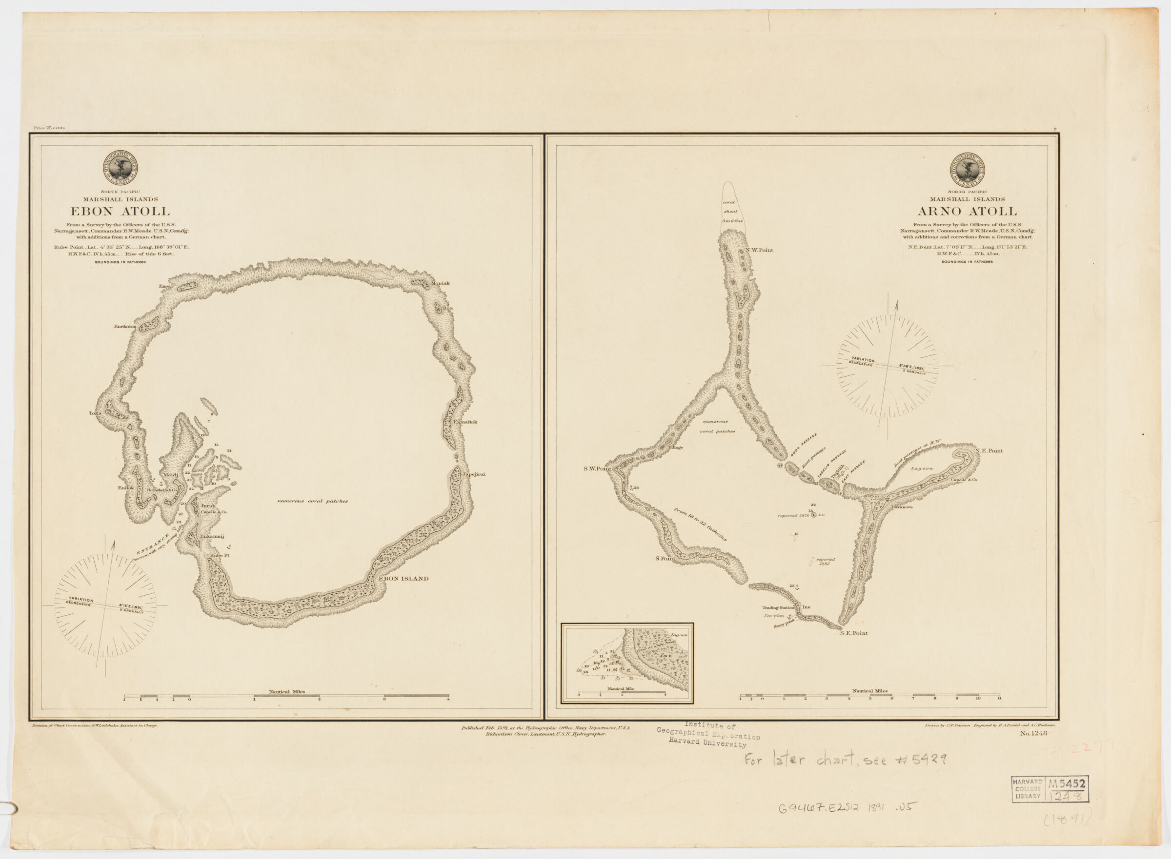
- North Pacific Marshall Islands Ebon Atoll. North Pacific Marshall Islands Arno Atoll ; Ebon Atoll ; Arno Atoll ; North Pacific Marshall Islands Arno Atoll
- United States, Hydrographic Office., creator
Meade, Richard W. (Richard Worsam), 1837-1897
Daniel, R. A.
Peterson, C. F.
Ruebsam, A. C.
Clover, Richardson
Littlehales, G. W. (George Washington), 1860-1943 - from a survey by the Officers of the U.S.S. Narragansett, Commander R.W. Meade, U.S.N. Comd'g ; with additions and corrections from a German chart ; division of chart construction G. W. Littlehales, assistant in charge ; drawn by C.F. Peterson ; engraved by R. A. Daniel and A.C. Ruebsam.
- 1891
- District of Columbia
[Washington, D.C.] - Hydrographic Office, Navy Department
- 2 maps on 1 sheet ; each 33 x 29 cm., on sheet 49 x 67 cm.
- English
- map
Maps - Images
- Narraganset (Ship)--Travel
Nautical charts--Marshall Islands--Ralik Chain
Ralik Chain (Marshall Islands)--Discovery and exploration--Maps
Arno Atoll (Marshall Islands)--Discovery and exploration--Maps - Depth shown by soundings.
Map of Arno Atoll includes inset of lagoon at N.E. point.
Below lower margin: Richardson Clover, Lieutenant, U.S.N., Hydrographer.
"No. 1248." - Open Collections Program at Harvard University
- Harvard Map Collection, Harvard University
- 990115392790203941
- Title
- North Pacific Marshall Islands Ebon Atoll. North Pacific Marshall Islands Arno Atoll ; Ebon Atoll ; Arno Atoll ; North Pacific Marshall Islands Arno Atoll
- Creator / Contributor
- United States, Hydrographic Office., creator
Meade, Richard W. (Richard Worsam), 1837-1897
Daniel, R. A.
Peterson, C. F.
Ruebsam, A. C.
Clover, Richardson
Littlehales, G. W. (George Washington), 1860-1943 - Attribution
- from a survey by the Officers of the U.S.S. Narragansett, Commander R.W. Meade, U.S.N. Comd'g ; with additions and corrections from a German chart ; division of chart construction G. W. Littlehales, assistant in charge ; drawn by C.F. Peterson ; engraved by R. A. Daniel and A.C. Ruebsam.
- Date
- 1891
- Place of Origin
- District of Columbia
[Washington, D.C.] - Publisher
- Hydrographic Office, Navy Department
- Extent
- 2 maps on 1 sheet ; each 33 x 29 cm., on sheet 49 x 67 cm.
- Language
- English
- Genre
- map
Maps - Digital Format
- Images
- Subjects
- Narraganset (Ship)--Travel
Nautical charts--Marshall Islands--Ralik Chain
Ralik Chain (Marshall Islands)--Discovery and exploration--Maps
Arno Atoll (Marshall Islands)--Discovery and exploration--Maps - Notes
- Depth shown by soundings.
Map of Arno Atoll includes inset of lagoon at N.E. point.
Below lower margin: Richardson Clover, Lieutenant, U.S.N., Hydrographer.
"No. 1248." - Series
- Open Collections Program at Harvard University
- Repository
- Harvard Map Collection, Harvard University
- Record ID
- 990115392790203941
Tools & Related Links
- More item details
- HOLLIS Record
Contacts
-
Joseph deVeerLibrary Project Manager and Museum LiaisonErnst Mayr Library617-495-3946
-