- Title
- [Polynesian Islands]
- United States, Hydrographic Office., creator
Wyman, R. H. (Robert Harris), 1822-1882
Sherman & Smith
United States Exploring Expedition (1838-1842) - corrected July 1882 ... R.H. Wyman, Commo. U.S.N. Hydrographer to the Bureau of Navigation; eng. by Sherman & Smith, N.Y.
- [1887]
1887 - District of Columbia
Washington, D.C - Hydrographic Office
- Ed. of July 1887.
- 4 maps on 1 sheet ; 71 x 49 cm., each map 29 x 19 cm. or smaller
- English
- map
government publication
Maps - Images
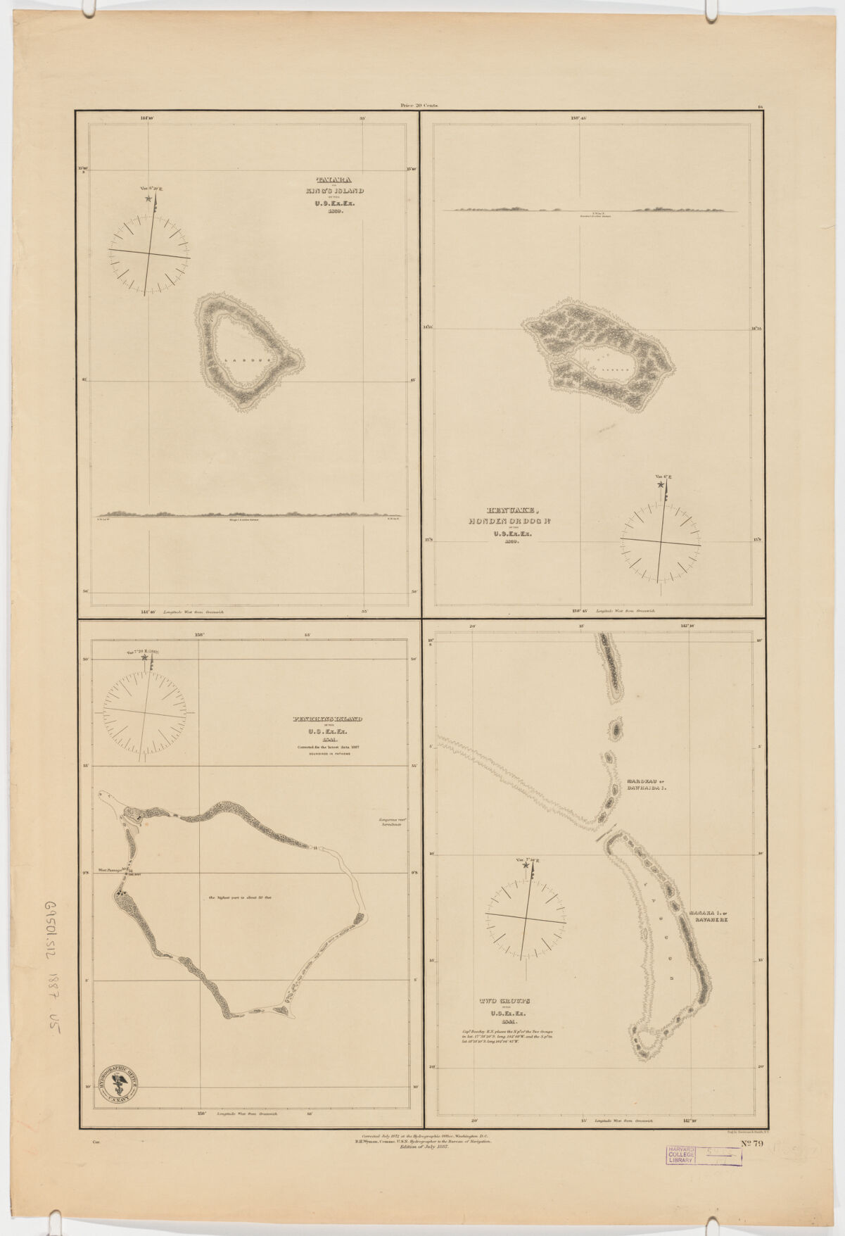
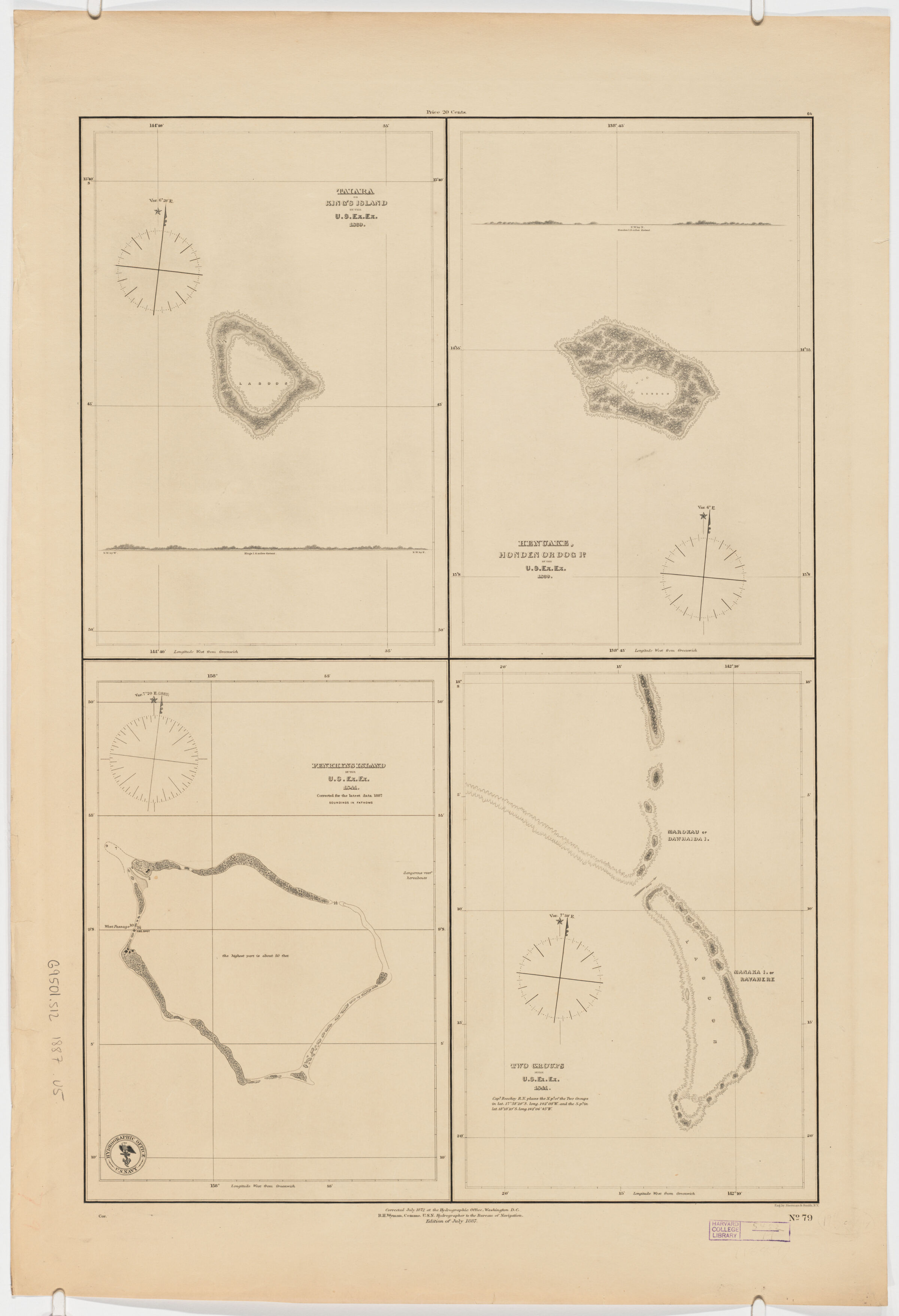
- Taiara or King's Island / by the U.S. Ex. Ex. 1839 includes profile, scale [ca. 1:63,360] -- Henuake, Honden or Dog I[d] / by the U.S. Ex. Ex. 1839 includes profile, scale [ca. 1:63,360] -- Penrhyns Island / by the U.S. Ex. Ex. 1841; corrected for the latest data 1887 scale [ca. 1:12,500]-- Two Groups [Marokau or Dawhaida I. Manaaka I. or Ravahere] / by the U.S. Ex. Ex. 1841 includes note, scale [ca. 1:12,500].
- Nautical charts--French Polynesia
Polynesia--Discovery and exploration--Maps
French Polynesia--Discovery and exploration--Maps
Penrhyn (Cook Islands)--Discovery and exploration--Maps
Tuamotu Archipelago (French Polynesia)--Discovery and exploration--Maps - "No. 79".
- Open Collections Program at Harvard University
Harvard Map Collection digital maps - Harvard Map Collection, Harvard University
- 990115175200203941
- Title
- [Polynesian Islands]
- Creator / Contributor
- United States, Hydrographic Office., creator
Wyman, R. H. (Robert Harris), 1822-1882
Sherman & Smith
United States Exploring Expedition (1838-1842) - Attribution
- corrected July 1882 ... R.H. Wyman, Commo. U.S.N. Hydrographer to the Bureau of Navigation; eng. by Sherman & Smith, N.Y.
- Date
- [1887]
1887 - Place of Origin
- District of Columbia
Washington, D.C - Publisher
- Hydrographic Office
- Edition
- Ed. of July 1887.
- Extent
- 4 maps on 1 sheet ; 71 x 49 cm., each map 29 x 19 cm. or smaller
- Language
- English
- Genre
- map
government publication
Maps - Digital Format
- Images
- Contents
- Taiara or King's Island / by the U.S. Ex. Ex. 1839 includes profile, scale [ca. 1:63,360] -- Henuake, Honden or Dog I[d] / by the U.S. Ex. Ex. 1839 includes profile, scale [ca. 1:63,360] -- Penrhyns Island / by the U.S. Ex. Ex. 1841; corrected for the latest data 1887 scale [ca. 1:12,500]-- Two Groups [Marokau or Dawhaida I. Manaaka I. or Ravahere] / by the U.S. Ex. Ex. 1841 includes note, scale [ca. 1:12,500].
- Subjects
- Nautical charts--French Polynesia
Polynesia--Discovery and exploration--Maps
French Polynesia--Discovery and exploration--Maps
Penrhyn (Cook Islands)--Discovery and exploration--Maps
Tuamotu Archipelago (French Polynesia)--Discovery and exploration--Maps - Notes
- "No. 79".
- Series
- Open Collections Program at Harvard University
Harvard Map Collection digital maps - Repository
- Harvard Map Collection, Harvard University
- Record ID
- 990115175200203941
Tools & Related Links
- More item details
- HOLLIS Record
Contacts
-
Joseph deVeerLibrary Project Manager and Museum LiaisonErnst Mayr Library617-495-3946
-