- Title
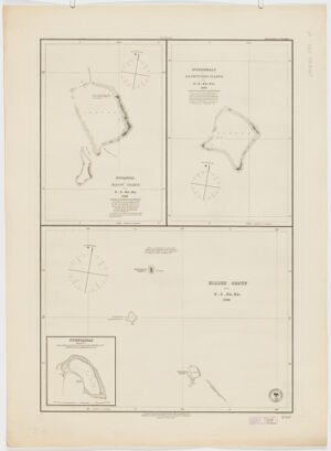
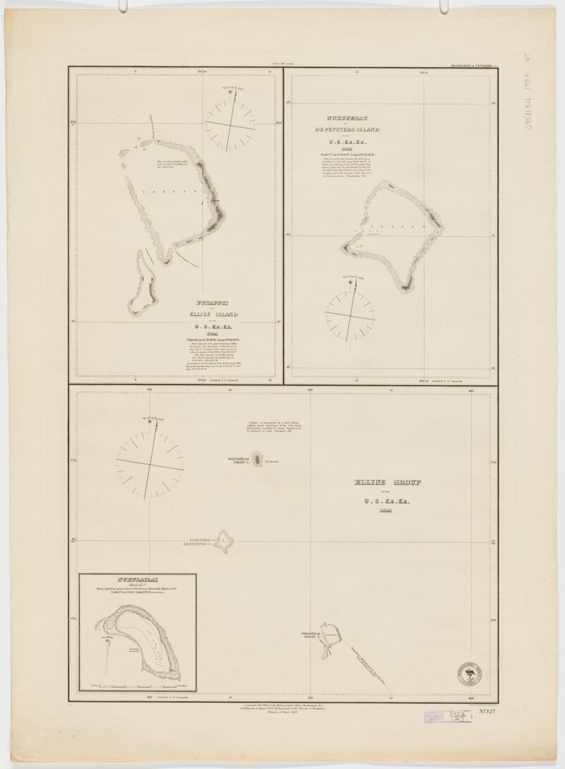
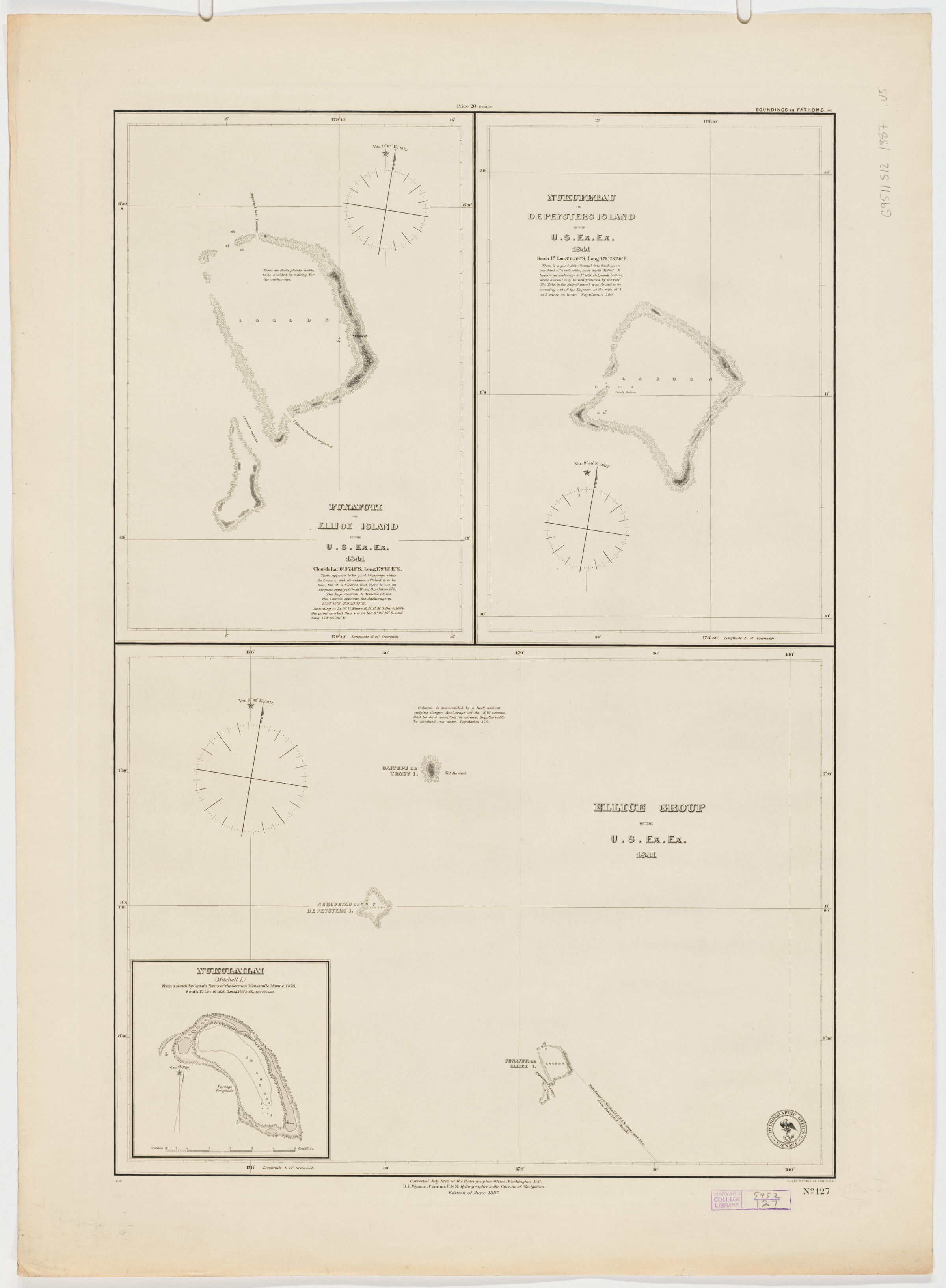
- Ellice Group. Funafuti or Ellice Island. Nukufetau or De Peysters Island ; Funaftuti or Ellice Island ; Nukufetau or De Peysters Island
- United States, Hydrographic Office., creator
Wyman, R. H. (Robert Harris), 1822-1882
Sherman & Smith
United States Exploring Expedition (1838-1842) - by the U.S. Ex. Ex. 1841; corrected July 1872 at the Hydrographic Office, Washington D.C.; R.H. Wyman Commo U.S.N. Hydrographer to the Bureau of Navigation; Sherman & Smith, N.Y.
- 1887
- District of Columbia
Washington D.C - U.S. Hydrographic Office
- Ed. of June 1887.
- 3 maps on 1 sheet ; 60 x 40 cm., each map 30 x 40 cm. or smaller.
- English
- map
government publication
Maps - Images
- Nautical charts--Tuvalu
Tuvalu--Discoveries and exploration--Maps
Funafuti Atoll (Tuvalu)--Discoveries and exploration--Maps
Nukufetau (Tuvalu)--Discoveries and exploration--Maps - Relief shown by spot heights. Depths shown by soundings.
Inset: Nukulailai (Mitchell I.) from a sketch of by Captain Peters of the German Mercantile Marine expedition, 1876.
Contains notes on the voyage.
"No. 127". - Open Collections Program at Harvard University
Harvard Map Collection digital maps - Harvard Map Collection, Harvard University
- 990115144710203941
- Title
- Ellice Group. Funafuti or Ellice Island. Nukufetau or De Peysters Island ; Funaftuti or Ellice Island ; Nukufetau or De Peysters Island
- Creator / Contributor
- United States, Hydrographic Office., creator
Wyman, R. H. (Robert Harris), 1822-1882
Sherman & Smith
United States Exploring Expedition (1838-1842) - Attribution
- by the U.S. Ex. Ex. 1841; corrected July 1872 at the Hydrographic Office, Washington D.C.; R.H. Wyman Commo U.S.N. Hydrographer to the Bureau of Navigation; Sherman & Smith, N.Y.
- Date
- 1887
- Place of Origin
- District of Columbia
Washington D.C - Publisher
- U.S. Hydrographic Office
- Edition
- Ed. of June 1887.
- Extent
- 3 maps on 1 sheet ; 60 x 40 cm., each map 30 x 40 cm. or smaller.
- Language
- English
- Genre
- map
government publication
Maps - Digital Format
- Images
- Subjects
- Nautical charts--Tuvalu
Tuvalu--Discoveries and exploration--Maps
Funafuti Atoll (Tuvalu)--Discoveries and exploration--Maps
Nukufetau (Tuvalu)--Discoveries and exploration--Maps - Notes
- Relief shown by spot heights. Depths shown by soundings.
Inset: Nukulailai (Mitchell I.) from a sketch of by Captain Peters of the German Mercantile Marine expedition, 1876.
Contains notes on the voyage.
"No. 127". - Series
- Open Collections Program at Harvard University
Harvard Map Collection digital maps - Repository
- Harvard Map Collection, Harvard University
- Record ID
- 990115144710203941
Tools & Related Links
- More item details
- HOLLIS Record
Contacts
-
Joseph deVeerLibrary Project Manager and Museum LiaisonErnst Mayr Library617-495-3946
-