- Title
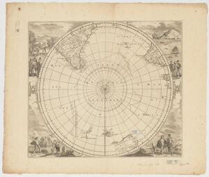
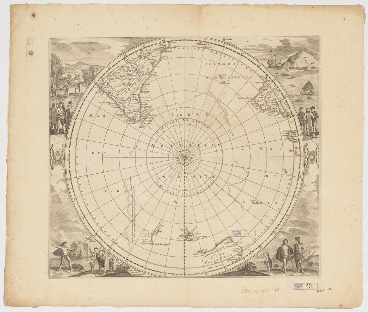
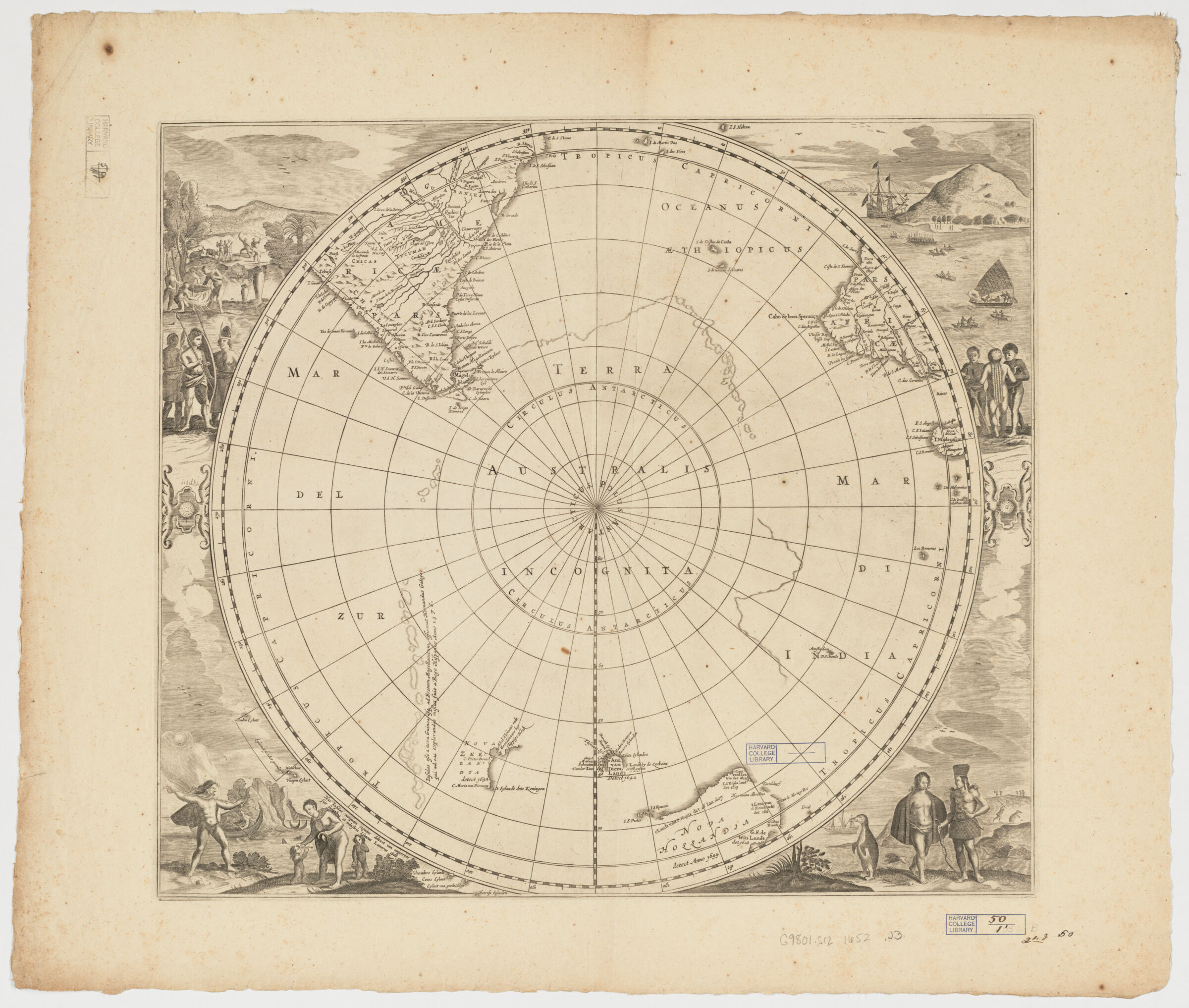
- Terra Australis incognita
- Jansson, Jan, 1588-1664, creator
- 1652]
1652 - Netherlands
[Amstelodami - apud Ioannem Ianssonium
- 1 map : ill. ; 44 x 49 cm.
- Dutch; Flemish
- map
Early maps
Maps
Engraving, Dutch-17th century.
Early works to 1800 - Images
- Discoveries in geography--17th century--Maps
Antarctica--Discovery and exploration--Maps--Early works to 1800
Australia--Discovery and exploration--Maps--Early works to 1800 - Covers South Pole to the Tropic of Capricorn and southern parts of South America, South Africa and the west and south coasts of Australia.
Relief shown pictorially.
Appears in: Nieuwen atlas ofte werelt-beschrijvinge vertoonende de vorornaemste rijcken ende landen ... Amsterdam: Ioannem Ianssonium, 1658-1687.
State lacking text on verso.
Historiated corners including natives, animals, birds, boats and a penguin and hunted penguin.
Includes notes.
"Nova Hollandia detect Anno 1644" refers to Tasman's second voyage.
In Dutch and Latin. - Open Collections Program at Harvard University
Harvard Map Collection digital maps - Harvard Map Collection, Harvard University
- 990115048730203941
- Title
- Terra Australis incognita
- Creator / Contributor
- Jansson, Jan, 1588-1664, creator
- Date
- 1652]
1652 - Place of Origin
- Netherlands
[Amstelodami - Publisher
- apud Ioannem Ianssonium
- Extent
- 1 map : ill. ; 44 x 49 cm.
- Language
- Dutch; Flemish
- Genre
- map
Early maps
Maps
Engraving, Dutch-17th century.
Early works to 1800 - Digital Format
- Images
- Subjects
- Discoveries in geography--17th century--Maps
Antarctica--Discovery and exploration--Maps--Early works to 1800
Australia--Discovery and exploration--Maps--Early works to 1800 - Notes
- Covers South Pole to the Tropic of Capricorn and southern parts of South America, South Africa and the west and south coasts of Australia.
Relief shown pictorially.
Appears in: Nieuwen atlas ofte werelt-beschrijvinge vertoonende de vorornaemste rijcken ende landen ... Amsterdam: Ioannem Ianssonium, 1658-1687.
State lacking text on verso.
Historiated corners including natives, animals, birds, boats and a penguin and hunted penguin.
Includes notes.
"Nova Hollandia detect Anno 1644" refers to Tasman's second voyage.
In Dutch and Latin. - Series
- Open Collections Program at Harvard University
Harvard Map Collection digital maps - Repository
- Harvard Map Collection, Harvard University
- Record ID
- 990115048730203941
Tools & Related Links
- More item details
- HOLLIS Record
Contacts
-
Joseph deVeerLibrary Project Manager and Museum LiaisonErnst Mayr Library617-495-3946
-