-
Title
-
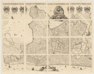
'T Hoogh-Heemraetschap vande uytwaterende sluysen in Kennemerlandt ende West-Vrieslandt
-
- Dou, Jan Jansz., 1615-1682, creator, printer.
Decker, Koenraedt, engraver.
Deur, Abraham Jansz., engraver.
Leth, Hendrik de, 1703-1766, printer.
-
- afgemeten en afgeteijckent deur Iohannes Douw, ordinaris landtmeter des landts van Rhynlandt ; Koenraet Decker sculpsit ; Abraham Deur scripsit.
-
- 1730
[1730?]
-
- Netherlands
[Amsterdam] :
-
- [Hendrik de Leth],
-
- 1 map on 16 sheets ; 172 x 232 cm, sheets 58 x 89 cm, or smaller
-
- Dutch; Flemish
-
- map
cartographic image
Early maps.
Topographic maps.
Pictorial works
Early works to 1800
-
- Images
-
- Heraldry--Netherlands--Pictorial works
Kennemerland (Netherlands)--Maps--Early works to 1800
Westfriesland (Netherlands)--Maps--Early works to 1800
-
- Above the map are the coats of arms of the Hoogheemraadschap's officials.
Relief shown pictorially.
Oriented with East on top.
Also available online.
-
- Harvard Map Collection digital maps
-
- G6003.F7 1730 .D6
-
- Harvard Map Collection, Harvard University
-
- 990137752320203941
-
Title
-
'T Hoogh-Heemraetschap vande uytwaterende sluysen in Kennemerlandt ende West-Vrieslandt
-
Creator / Contributor
- Dou, Jan Jansz., 1615-1682, creator, printer.
Decker, Koenraedt, engraver.
Deur, Abraham Jansz., engraver.
Leth, Hendrik de, 1703-1766, printer.
-
Attribution
- afgemeten en afgeteijckent deur Iohannes Douw, ordinaris landtmeter des landts van Rhynlandt ; Koenraet Decker sculpsit ; Abraham Deur scripsit.
-
Date
- 1730
[1730?]
-
Place of Origin
- Netherlands
[Amsterdam] :
-
Publisher
- [Hendrik de Leth],
-
Extent
- 1 map on 16 sheets ; 172 x 232 cm, sheets 58 x 89 cm, or smaller
-
Language
- Dutch; Flemish
-
Genre
- map
cartographic image
Early maps.
Topographic maps.
Pictorial works
Early works to 1800
-
Digital Format
- Images
-
Subjects
- Heraldry--Netherlands--Pictorial works
Kennemerland (Netherlands)--Maps--Early works to 1800
Westfriesland (Netherlands)--Maps--Early works to 1800
-
Notes
- Above the map are the coats of arms of the Hoogheemraadschap's officials.
Relief shown pictorially.
Oriented with East on top.
Also available online.
-
Series
- Harvard Map Collection digital maps
-
Classification
- G6003.F7 1730 .D6
-
Repository
- Harvard Map Collection, Harvard University
-
Record ID
- 990137752320203941