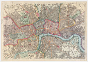
Shows names of streets, bridges, parks, railways, drainage, district divisions and other points of interest. Originally issued in booklet with index of streets (16 p.); advertisements on map verso. Available also as a digital image through the Harvard University Web site. Electronic reproduction. Cambridge, Mass. : Harvard Geospatial Library, 2008 Georeferenced image for use in a GIS.
Shows names of streets, bridges, parks, railways, drainage, district divisions and other points of interest. Originally issued in booklet with index of streets (16 p.); advertisements on map verso. Available also as a digital image through the Harvard University Web site. Electronic reproduction. Cambridge, Mass. : Harvard Geospatial Library, 2008 Georeferenced image for use in a GIS.