- Title
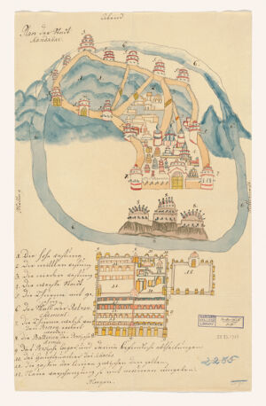
- Plan van Fort Kandahar
- [approximately 1738?]
1738 - No place, unknown, or undetermined
- 1 ms. map : color ; 38 x 24 cm
- Dutch; Flemish
- map
cartographic image
Aerial views
Manuscript maps
Early works
Pictorial maps
Early works to 1800
Maps - Images
- Manuscript maps--Early works to 1800
Kandahār (Afghanistan)--Maps--Early works to 1800
Kandahār (Afghanistan)--Aerial views--Early works to 1800
Manuscript maps
Afghanistan--Kandahār - Pictorial map.
Probably executed by an artist witnessing Nader Shah's siege of Kandahar, which began in 1738.
Pen-and-ink and watercolor.
Includes index to points of interest.
Available also as a digital image through the Harvard University Library Web site. - Harvard Map Collection digital maps
- G7634.K25A5 1738 .P5
- Harvard Map Collection, Harvard University
- 990097048440203941
- Title
- Plan van Fort Kandahar
- Date
- [approximately 1738?]
1738 - Place of Origin
- No place, unknown, or undetermined
- Extent
- 1 ms. map : color ; 38 x 24 cm
- Language
- Dutch; Flemish
- Genre
- map
cartographic image
Aerial views
Manuscript maps
Early works
Pictorial maps
Early works to 1800
Maps - Digital Format
- Images
- Subjects
- Manuscript maps--Early works to 1800
Kandahār (Afghanistan)--Maps--Early works to 1800
Kandahār (Afghanistan)--Aerial views--Early works to 1800
Manuscript maps
Afghanistan--Kandahār - Notes
- Pictorial map.
Probably executed by an artist witnessing Nader Shah's siege of Kandahar, which began in 1738.
Pen-and-ink and watercolor.
Includes index to points of interest.
Available also as a digital image through the Harvard University Library Web site. - Series
- Harvard Map Collection digital maps
- Classification
- G7634.K25A5 1738 .P5
- Repository
- Harvard Map Collection, Harvard University
- Record ID
- 990097048440203941
Tools & Related Links
- More item details
- HOLLIS Record
Contacts
-
617-495-2417