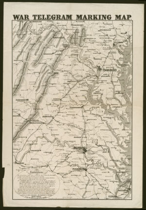
Relief shown by hachures. Base map depicting eastern Virginia printed in black ink. "Entered according to Act of Congress in the year 1862 by L. Prang & Co. in the Clerks Office of the District Court of Massachusetts." "Explanations. The extraordinary large scale on which this map is drawn has been adopted to make it just what we designed it to be, namely 1st. The most distinct map ever published of the whole Virginia territory, where the decisive battles for the Union will be fought. 2nd. A marking map, that is a map to mark the change of positions of the Union forces in red pencil and the rebel forces in blue, on the receipt of every telegram from the seat of war..." Includes text. Available also as a digital image through the Harvard University Web site. Electronic reproduction. Cambridge, Mass. : Harvard Geospatial Library, 2007 Georeferenced image for use in a GIS.
Relief shown by hachures. Base map depicting eastern Virginia printed in black ink. "Entered according to Act of Congress in the year 1862 by L. Prang & Co. in the Clerks Office of the District Court of Massachusetts." "Explanations. The extraordinary large scale on which this map is drawn has been adopted to make it just what we designed it to be, namely 1st. The most distinct map ever published of the whole Virginia territory, where the decisive battles for the Union will be fought. 2nd. A marking map, that is a map to mark the change of positions of the Union forces in red pencil and the rebel forces in blue, on the receipt of every telegram from the seat of war..." Includes text. Available also as a digital image through the Harvard University Web site. Electronic reproduction. Cambridge, Mass. : Harvard Geospatial Library, 2007 Georeferenced image for use in a GIS.