-
Title
-
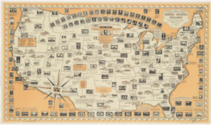
The pictorial map, United States stamps ; United States stamps
-
- Chase, Ernest Dudley, 1878-1966, creator
-
- designed, drawn, and published by Ernest Dudley Chase ; research directors, Charles Peck Kerr and Rupert Frank Jones.
-
- [1949]
1949
-
- Massachusetts
Winchester, Mass
-
- Chase
-
- 1 map : col. ; 51 x 89 cm.
-
- English
-
- map
Maps
-
- Images
-
- Stamp collecting--United States--Maps
United States--Maps, Pictorial
-
- Includes list of "Postage firsts" and historical notes.
-
- Harvard Map Collection digital maps
-
- G3701.P8 1949 .C5
-
- Harvard Map Collection, Harvard University
-
- 990038264700203941
-
Title
-
The pictorial map, United States stamps ; United States stamps
-
Creator / Contributor
- Chase, Ernest Dudley, 1878-1966, creator
-
Attribution
- designed, drawn, and published by Ernest Dudley Chase ; research directors, Charles Peck Kerr and Rupert Frank Jones.
-
Date
- [1949]
1949
-
Place of Origin
- Massachusetts
Winchester, Mass
-
Publisher
- Chase
-
Extent
- 1 map : col. ; 51 x 89 cm.
-
Language
- English
-
Genre
- map
Maps
-
Digital Format
- Images
-
Subjects
- Stamp collecting--United States--Maps
United States--Maps, Pictorial
-
Notes
- Includes list of "Postage firsts" and historical notes.
-
Series
- Harvard Map Collection digital maps
-
Classification
- G3701.P8 1949 .C5
-
Repository
- Harvard Map Collection, Harvard University
-
Record ID
- 990038264700203941