-
Title
-
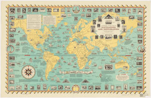
A pictorial stamp map of navigation and exploration ; Stamp map of navigation and exploration
-
- Chase, Ernest Dudley, 1878-1966, creator
Lang, Katharine Birdseye.
-
- designed, drawn, and published by Ernest Dudley Chase ; Katharine Birdseye Lang, collaborator.
-
- [1951]
1951
-
- Massachusetts
Winchester, Mass
-
- Chase
-
- 1 map : col. ; 51 x 82 cm.
-
- English
-
- map
Maps
-
- Images
-
- Stamp collecting--Maps
World maps, Pictorial
-
- Includes historical notes.
-
- Harvard Map Collection digital maps
-
- G3201.P8 1951 .C5
-
- Harvard Map Collection, Harvard University
-
- 990029116110203941
-
Title
-
A pictorial stamp map of navigation and exploration ; Stamp map of navigation and exploration
-
Creator / Contributor
- Chase, Ernest Dudley, 1878-1966, creator
Lang, Katharine Birdseye.
-
Attribution
- designed, drawn, and published by Ernest Dudley Chase ; Katharine Birdseye Lang, collaborator.
-
Date
- [1951]
1951
-
Place of Origin
- Massachusetts
Winchester, Mass
-
Publisher
- Chase
-
Extent
- 1 map : col. ; 51 x 82 cm.
-
Language
- English
-
Genre
- map
Maps
-
Digital Format
- Images
-
Subjects
- Stamp collecting--Maps
World maps, Pictorial
-
Notes
- Includes historical notes.
-
Series
- Harvard Map Collection digital maps
-
Classification
- G3201.P8 1951 .C5
-
Repository
- Harvard Map Collection, Harvard University
-
Record ID
- 990029116110203941