- Title
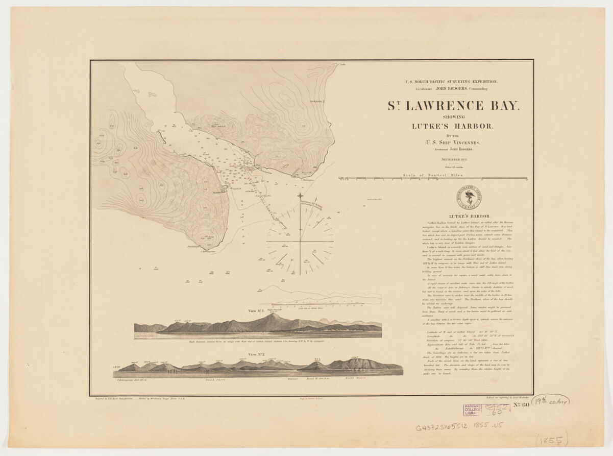
- St. Lawrence Bay showing Lutke's Harbor
- United States, Hydrographic Office., creator
Rodgers, John, 1812-1882
Boggs, William Brenton, 1809-1875
Knorr, E. R. (Ernest Rudolph)
Waldecker, Louis.
Siebert, Selmar. - by the U.S. Ship Vincennes, Lieutenant John Rodgers ; produced by E.R. Knorr, draughtsman ; sketches by Wm. Brenton Boggs, purser U.S.N. ; engr. by Selmar Siebert ; reduced for engraving by Louis Waldecker.
- 1855
- District of Columbia
[Washington, D.C.] - U.S. Navy Hydrographic Office
- 1 map ; 21 x 24 cm., on sheet 32 x 42 cm.
- English
- map
Maps - Images
- Vincennes (Cruiser)
Harbors--Alaska--Saint Lawrence Island--Maps
Nautical charts--Alaska--Saint Lawrence Island
Saint Lawrence Island (Alaska)--Discovery and exploration--Maps - Relief shown by contours and spot heights. Depths shown by soundings.
Includes note on Lutke's Harbor.
2 inset profile views.
"No. 60."
Also available online.
Electronic reproduction. Cambridge, Mass. : Harvard Geospatial Library, 2011. Georeferenced image for use in a GIS. - Open Collections Program at Harvard University
- Harvard Map Collection, Harvard University
- 990115391150203941
- Title
- St. Lawrence Bay showing Lutke's Harbor
- Creator / Contributor
- United States, Hydrographic Office., creator
Rodgers, John, 1812-1882
Boggs, William Brenton, 1809-1875
Knorr, E. R. (Ernest Rudolph)
Waldecker, Louis.
Siebert, Selmar. - Attribution
- by the U.S. Ship Vincennes, Lieutenant John Rodgers ; produced by E.R. Knorr, draughtsman ; sketches by Wm. Brenton Boggs, purser U.S.N. ; engr. by Selmar Siebert ; reduced for engraving by Louis Waldecker.
- Date
- 1855
- Place of Origin
- District of Columbia
[Washington, D.C.] - Publisher
- U.S. Navy Hydrographic Office
- Extent
- 1 map ; 21 x 24 cm., on sheet 32 x 42 cm.
- Language
- English
- Genre
- map
Maps - Digital Format
- Images
- Subjects
- Vincennes (Cruiser)
Harbors--Alaska--Saint Lawrence Island--Maps
Nautical charts--Alaska--Saint Lawrence Island
Saint Lawrence Island (Alaska)--Discovery and exploration--Maps - Notes
- Relief shown by contours and spot heights. Depths shown by soundings.
Includes note on Lutke's Harbor.
2 inset profile views.
"No. 60."
Also available online.
Electronic reproduction. Cambridge, Mass. : Harvard Geospatial Library, 2011. Georeferenced image for use in a GIS. - Series
- Open Collections Program at Harvard University
- Repository
- Harvard Map Collection, Harvard University
- Record ID
- 990115391150203941
Tools & Related Links
- More item details
- HOLLIS Record
Contacts
-
Joseph deVeerLibrary Project Manager and Museum LiaisonErnst Mayr Library617-495-3946
-