- Title
- [Asaua Group]
- United States, Hydrographic Office., creator
Wyman, R. H. (Robert Harris), 1822-1882
United States Exploring Expedition (1838-1842) - by the U.S.Ex.Ex. 1840; corrected Novbr. 1872; R.H. Wyman Commo U.S.N. Hydrographer to the Bureau of Navigation.
- [1889]
1889 - District of Columbia
Washington, D.C - Hydrographic Office
- Ed. of July 1889.
- 4 maps on 1 sheet ; each map 29 x 20 cm., on sheet 72 x 49 cm.
- English
- map
government publication
Maps - Images
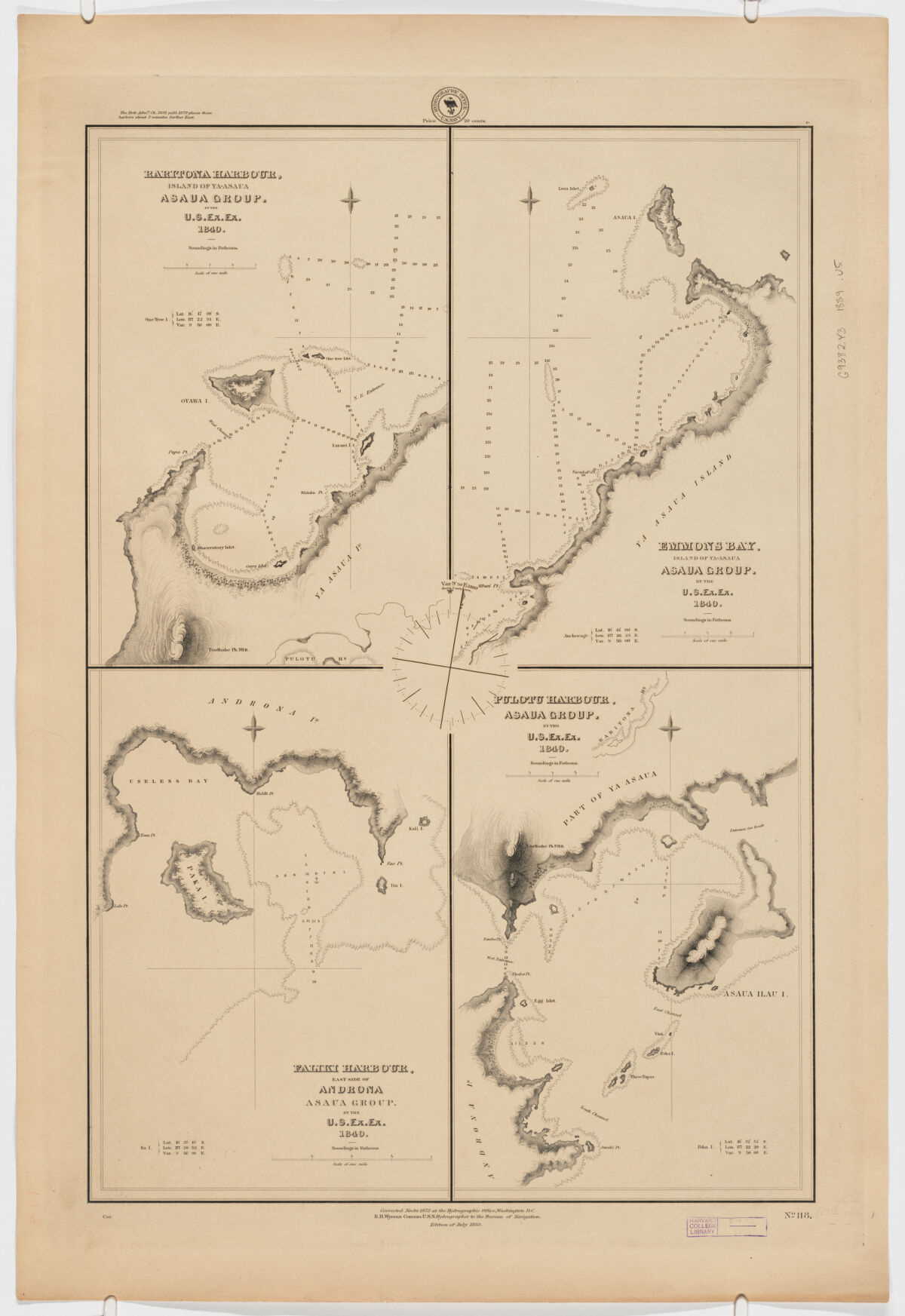
- Raritona Harbour, Island of Ya-Asaua, Asaua Group Scale [ca. 1: 31,000] -- Emmons Bay, Island of Ya-Asaua, Asaua Group Scale [ca. 1: 31,000] -- Faliki Harbour, east side of Androna, Asaua Group Scale [ca. 1:18,500] -- Pulotu Harbour, Asaua Group Scale [ca. 1: 31,000].
- Harbors--Fiji--Yasawa Group--Maps
Nautical charts--Fiji--Yasawa Group
Yasawa Group (Fiji)--Discovery and exploration--Maps - Title supplied by cataloguer.
Relief shown by hachures. Depths shown by soundings.
"No. 118".
Includes note above upper left margin. - Open Collections Program at Harvard University
- Harvard Map Collection, Harvard University
- 990115382090203941
- Title
- [Asaua Group]
- Creator / Contributor
- United States, Hydrographic Office., creator
Wyman, R. H. (Robert Harris), 1822-1882
United States Exploring Expedition (1838-1842) - Attribution
- by the U.S.Ex.Ex. 1840; corrected Novbr. 1872; R.H. Wyman Commo U.S.N. Hydrographer to the Bureau of Navigation.
- Date
- [1889]
1889 - Place of Origin
- District of Columbia
Washington, D.C - Publisher
- Hydrographic Office
- Edition
- Ed. of July 1889.
- Extent
- 4 maps on 1 sheet ; each map 29 x 20 cm., on sheet 72 x 49 cm.
- Language
- English
- Genre
- map
government publication
Maps - Digital Format
- Images
- Contents
- Raritona Harbour, Island of Ya-Asaua, Asaua Group Scale [ca. 1: 31,000] -- Emmons Bay, Island of Ya-Asaua, Asaua Group Scale [ca. 1: 31,000] -- Faliki Harbour, east side of Androna, Asaua Group Scale [ca. 1:18,500] -- Pulotu Harbour, Asaua Group Scale [ca. 1: 31,000].
- Subjects
- Harbors--Fiji--Yasawa Group--Maps
Nautical charts--Fiji--Yasawa Group
Yasawa Group (Fiji)--Discovery and exploration--Maps - Notes
- Title supplied by cataloguer.
Relief shown by hachures. Depths shown by soundings.
"No. 118".
Includes note above upper left margin. - Series
- Open Collections Program at Harvard University
- Repository
- Harvard Map Collection, Harvard University
- Record ID
- 990115382090203941
Tools & Related Links
- More item details
- HOLLIS Record
Contacts
-
Joseph deVeerLibrary Project Manager and Museum LiaisonErnst Mayr Library617-495-3946
-