- Title
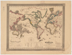
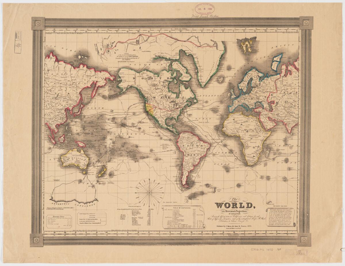
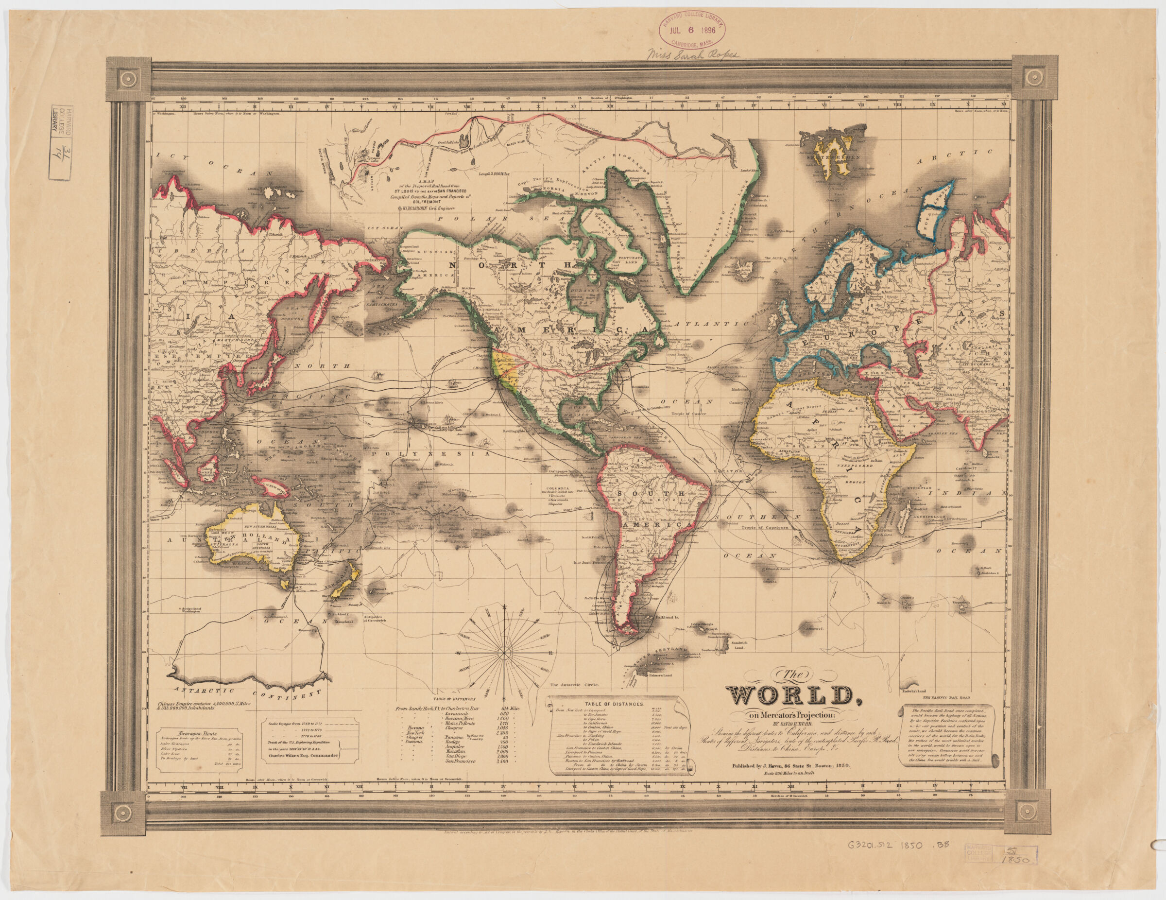
- The world, on Mercator's projection
- Burr, David H., 1803-1875, creator
Haven, John. - by David H. Burr.
- 1850
- Massachusetts
Boston - Published by J. Haven, 86 State St.
- 1 map : hand col. ; 42 x 53 cm.
- English
- map
Maps - Images
- World maps--Discovery and exploration
Ocean travel--Maps
Overland journeys to the Pacific--Maps - Relief shown by abbreviated form lines.
"Showing the different routes to California, and distance by each, routes of different navigators, route of the contemplated Pacific R. Road, distances to China, Europe, & c."
Prime meridian: Washington and Greenwich.
"Entered according to Act of Congress, in the year 1850, by John Haven in the clerks office of the District Court of the state of Massachusetts."
Includes historical notes, ship ill., tables of distances, "Nicaragua route" distances, and text on "Pacific Railroad."
Insets: Map of the Nicaragua route -- Map of the proposed rail road from St. Louis to the bay of St. Francisco.
Also available online.
Electronic reproduction. Cambridge, Mass. : Harvard Geospatial Library, 2011. Georeferenced image for use in a GIS. - Open Collections Program at Harvard University
- Harvard Map Collection, Harvard University
- 990115271960203941
- Title
- The world, on Mercator's projection
- Creator / Contributor
- Burr, David H., 1803-1875, creator
Haven, John. - Attribution
- by David H. Burr.
- Date
- 1850
- Place of Origin
- Massachusetts
Boston - Publisher
- Published by J. Haven, 86 State St.
- Extent
- 1 map : hand col. ; 42 x 53 cm.
- Language
- English
- Genre
- map
Maps - Digital Format
- Images
- Subjects
- World maps--Discovery and exploration
Ocean travel--Maps
Overland journeys to the Pacific--Maps - Notes
- Relief shown by abbreviated form lines.
"Showing the different routes to California, and distance by each, routes of different navigators, route of the contemplated Pacific R. Road, distances to China, Europe, & c."
Prime meridian: Washington and Greenwich.
"Entered according to Act of Congress, in the year 1850, by John Haven in the clerks office of the District Court of the state of Massachusetts."
Includes historical notes, ship ill., tables of distances, "Nicaragua route" distances, and text on "Pacific Railroad."
Insets: Map of the Nicaragua route -- Map of the proposed rail road from St. Louis to the bay of St. Francisco.
Also available online.
Electronic reproduction. Cambridge, Mass. : Harvard Geospatial Library, 2011. Georeferenced image for use in a GIS. - Series
- Open Collections Program at Harvard University
- Repository
- Harvard Map Collection, Harvard University
- Record ID
- 990115271960203941
Tools & Related Links
- More item details
- HOLLIS Record
Contacts
-
Joseph deVeerLibrary Project Manager and Museum LiaisonErnst Mayr Library617-495-3946
-