- Title
- [Oceania] / corrected August 1872 ... R.H. Wyman, Commo. U.S.N. Hydrographer to the Bureau of Navigation
- United States, Hydrographic Office., creator
Wyman, R. H. (Robert Harris), 1822-1882
United States Exploring Expedition (1838-1842) - 1890
- District of Columbia
Washington, D.C - Hydrographic Office
- 5 maps on 1 sheet ; 72 x 55 cm. each map 29 x 39 cm. or smaller.
- English
- map
government publication
Maps - Images
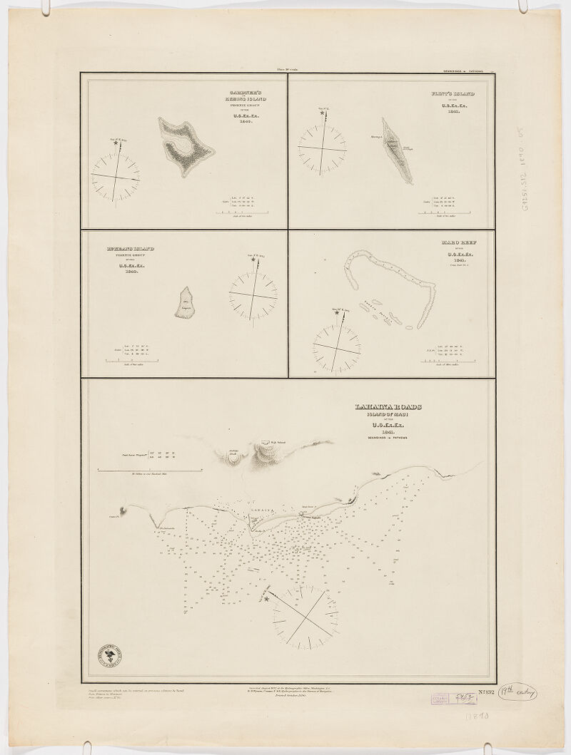
- Gardner's or Kemins Island, Phoenix Group / by the U.S. Ex.Ex. 1840 -- Flint's Island / by the U.S. Ex.Ex. 1841 -- McKean's Island, Phoenix Group / by the U.S. Ex. Ex. -- Maro reef / by the U.S. Ex. Ex. 1841 (comp. chart no. 2) -- Lahaina roads, Island of Maui / U.S. Ex.Ex. 1841.
- Nautical charts--Oceania
Oceania--Discovery and exploration--Maps
Phoenix Islands (Kiribati)--Discovery and exploration--Maps
Kiribati--Discovery and exploration--Maps
Maro Reef (Hawaii)--Discovery and exploration--Maps
Maui (Hawaii)--Discovery and exploration--Maps - Title supplied by cataloguer.
Relief shown by hachures. Depths shown by soundings.
"Printed 1890".
"No. 132".
Notes on corrections and additions below lower left margin.
Electronic reproduction. Cambridge, Mass. : Harvard Geospatial Library, 2014. Georeferenced image for use in a GIS. - Open Collections Program at Harvard University
- Harvard Map Collection, Harvard University
- 990115219300203941
- Title
- [Oceania] / corrected August 1872 ... R.H. Wyman, Commo. U.S.N. Hydrographer to the Bureau of Navigation
- Creator / Contributor
- United States, Hydrographic Office., creator
Wyman, R. H. (Robert Harris), 1822-1882
United States Exploring Expedition (1838-1842) - Date
- 1890
- Place of Origin
- District of Columbia
Washington, D.C - Publisher
- Hydrographic Office
- Extent
- 5 maps on 1 sheet ; 72 x 55 cm. each map 29 x 39 cm. or smaller.
- Language
- English
- Genre
- map
government publication
Maps - Digital Format
- Images
- Contents
- Gardner's or Kemins Island, Phoenix Group / by the U.S. Ex.Ex. 1840 -- Flint's Island / by the U.S. Ex.Ex. 1841 -- McKean's Island, Phoenix Group / by the U.S. Ex. Ex. -- Maro reef / by the U.S. Ex. Ex. 1841 (comp. chart no. 2) -- Lahaina roads, Island of Maui / U.S. Ex.Ex. 1841.
- Subjects
- Nautical charts--Oceania
Oceania--Discovery and exploration--Maps
Phoenix Islands (Kiribati)--Discovery and exploration--Maps
Kiribati--Discovery and exploration--Maps
Maro Reef (Hawaii)--Discovery and exploration--Maps
Maui (Hawaii)--Discovery and exploration--Maps - Notes
- Title supplied by cataloguer.
Relief shown by hachures. Depths shown by soundings.
"Printed 1890".
"No. 132".
Notes on corrections and additions below lower left margin.
Electronic reproduction. Cambridge, Mass. : Harvard Geospatial Library, 2014. Georeferenced image for use in a GIS. - Series
- Open Collections Program at Harvard University
- Repository
- Harvard Map Collection, Harvard University
- Record ID
- 990115219300203941
Tools & Related Links
- More item details
- HOLLIS Record
Contacts
-
Joseph deVeerLibrary Project Manager and Museum LiaisonErnst Mayr Library617-495-3946
-