- Title
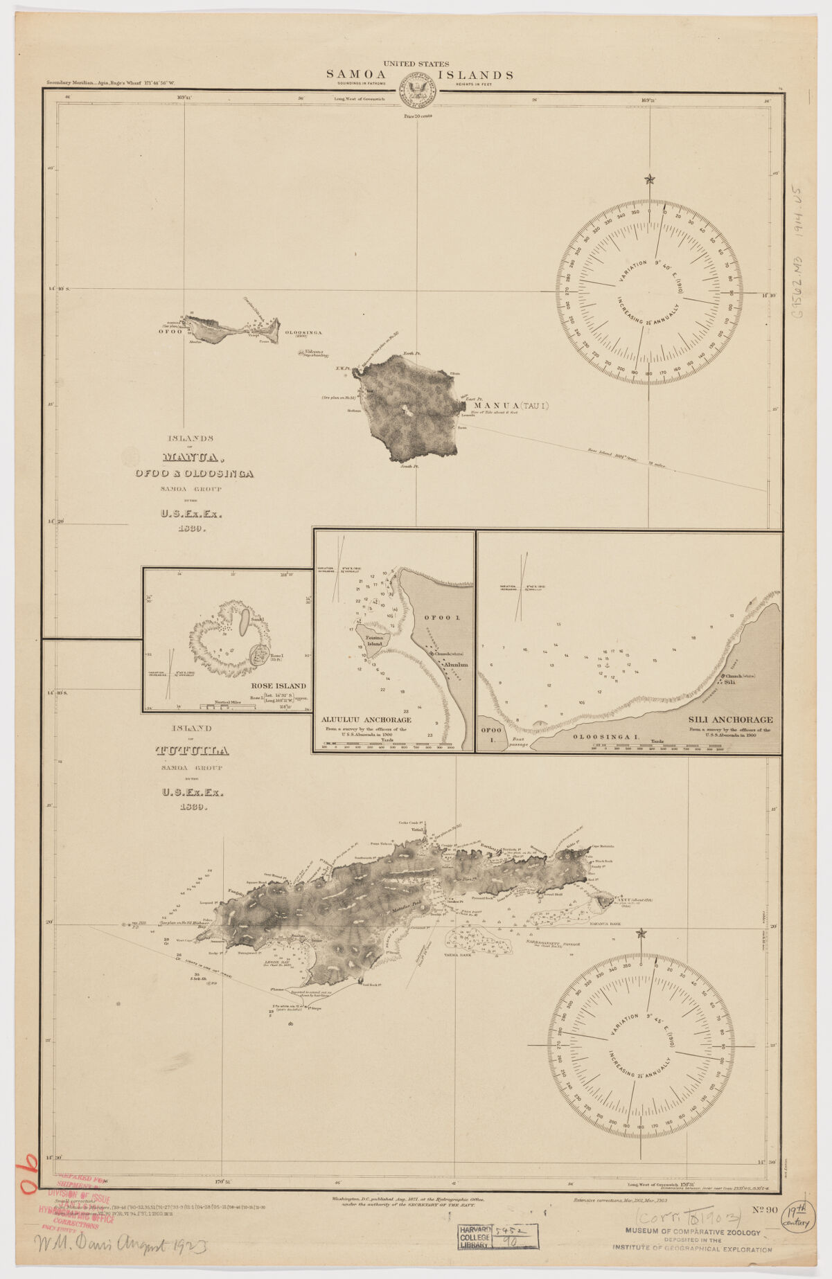
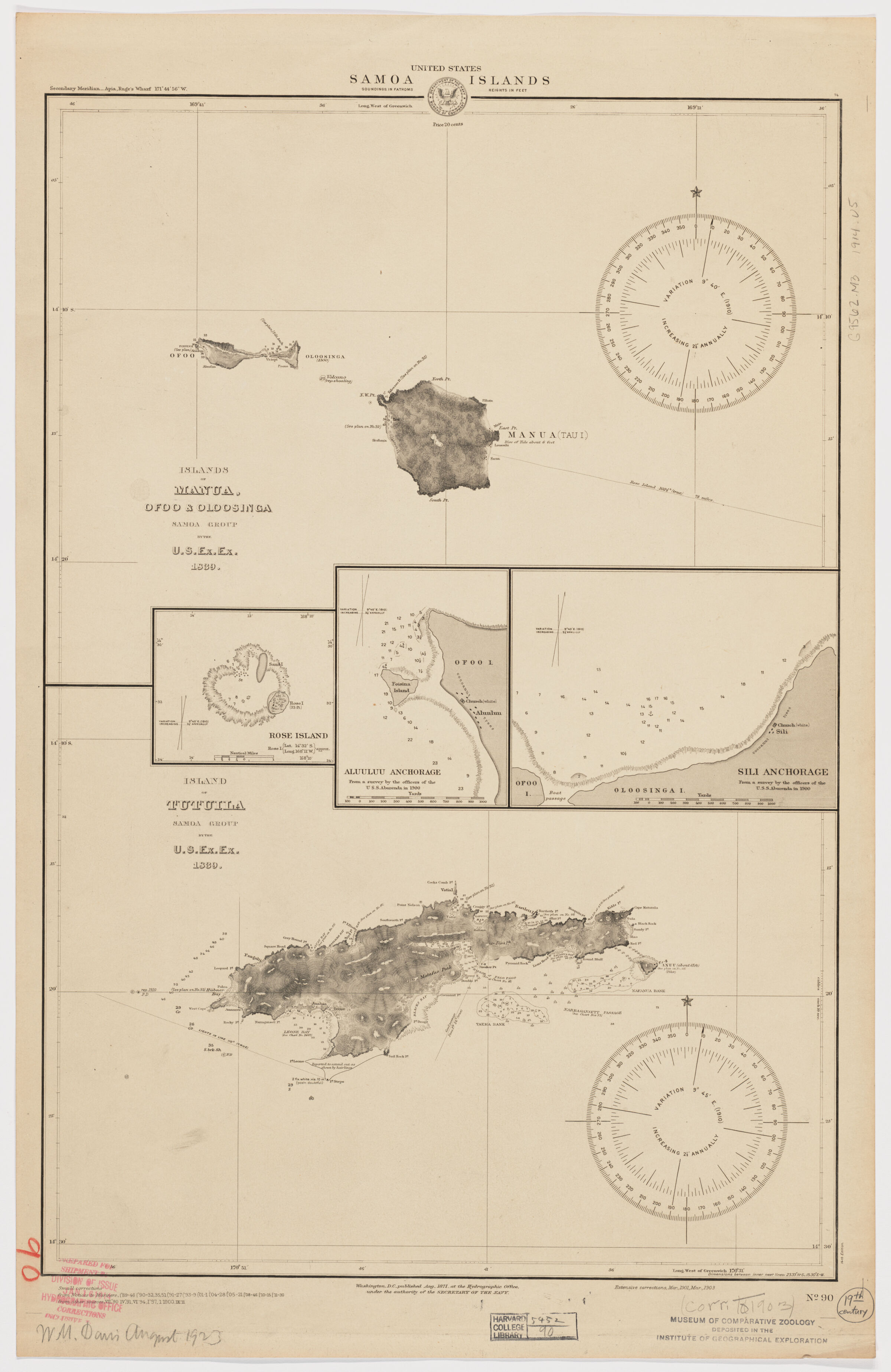
- Islands of Manua, Ofoo & Oloosinga, Samoan Group. Island of Tutuila, Samoan Group ; Island of Tutuila, Samoan Group ; United States. Samoa Islands
- United States, Hydrographic Office., creator
United States Exploring Expedition (1838-1842) - by the U.S. Ex. Ex. 1839; corrected Aug. 1871 under the authority of the Secretary of Navy; extensive corrections Mar. 1901, Mar. 1903.
- [1914]
1903 - District of Columbia
Washington, D.C - Hydrographic Office
- 14th ed.
- 2 maps on 1 sheet ; each 29 x 39 cm., on sheet 72 x 46 cm.
- English
- map
government publication
Maps - Images
- Nautical charts--American Samoa
Manua Islands (American Samoa)--Discovery and exploration--Maps
Tutuila Island (American Samoa)--Discovery and exploration--Maps - Relief shown by hachures. Depths shown by soundings.
Insets: Rose Island -- Aluuluu Anchorage / from a survey by the officers of the U.S.S. Abarenda in 1900 -- Sili Anchorage / from a survey by the officers of the U.S.S. Abarenda in 1900.
Notes on sources and editions dated to 1900.
"No. 90".
Electronic reproduction. Cambridge, Mass. : Harvard Geospatial Library, 2014. Georeferenced image for use in a GIS. - Open Collections Program at Harvard University
- Harvard Map Collection, Harvard University
- 990115166310203941
- Title
- Islands of Manua, Ofoo & Oloosinga, Samoan Group. Island of Tutuila, Samoan Group ; Island of Tutuila, Samoan Group ; United States. Samoa Islands
- Creator / Contributor
- United States, Hydrographic Office., creator
United States Exploring Expedition (1838-1842) - Attribution
- by the U.S. Ex. Ex. 1839; corrected Aug. 1871 under the authority of the Secretary of Navy; extensive corrections Mar. 1901, Mar. 1903.
- Date
- [1914]
1903 - Place of Origin
- District of Columbia
Washington, D.C - Publisher
- Hydrographic Office
- Edition
- 14th ed.
- Extent
- 2 maps on 1 sheet ; each 29 x 39 cm., on sheet 72 x 46 cm.
- Language
- English
- Genre
- map
government publication
Maps - Digital Format
- Images
- Subjects
- Nautical charts--American Samoa
Manua Islands (American Samoa)--Discovery and exploration--Maps
Tutuila Island (American Samoa)--Discovery and exploration--Maps - Notes
- Relief shown by hachures. Depths shown by soundings.
Insets: Rose Island -- Aluuluu Anchorage / from a survey by the officers of the U.S.S. Abarenda in 1900 -- Sili Anchorage / from a survey by the officers of the U.S.S. Abarenda in 1900.
Notes on sources and editions dated to 1900.
"No. 90".
Electronic reproduction. Cambridge, Mass. : Harvard Geospatial Library, 2014. Georeferenced image for use in a GIS. - Series
- Open Collections Program at Harvard University
- Repository
- Harvard Map Collection, Harvard University
- Record ID
- 990115166310203941
Tools & Related Links
- More item details
- HOLLIS Record
Contacts
-
Joseph deVeerLibrary Project Manager and Museum LiaisonErnst Mayr Library617-495-3946
-