- Title
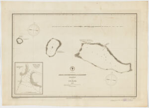
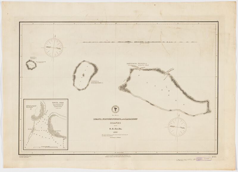
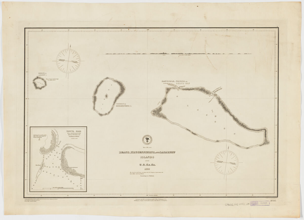
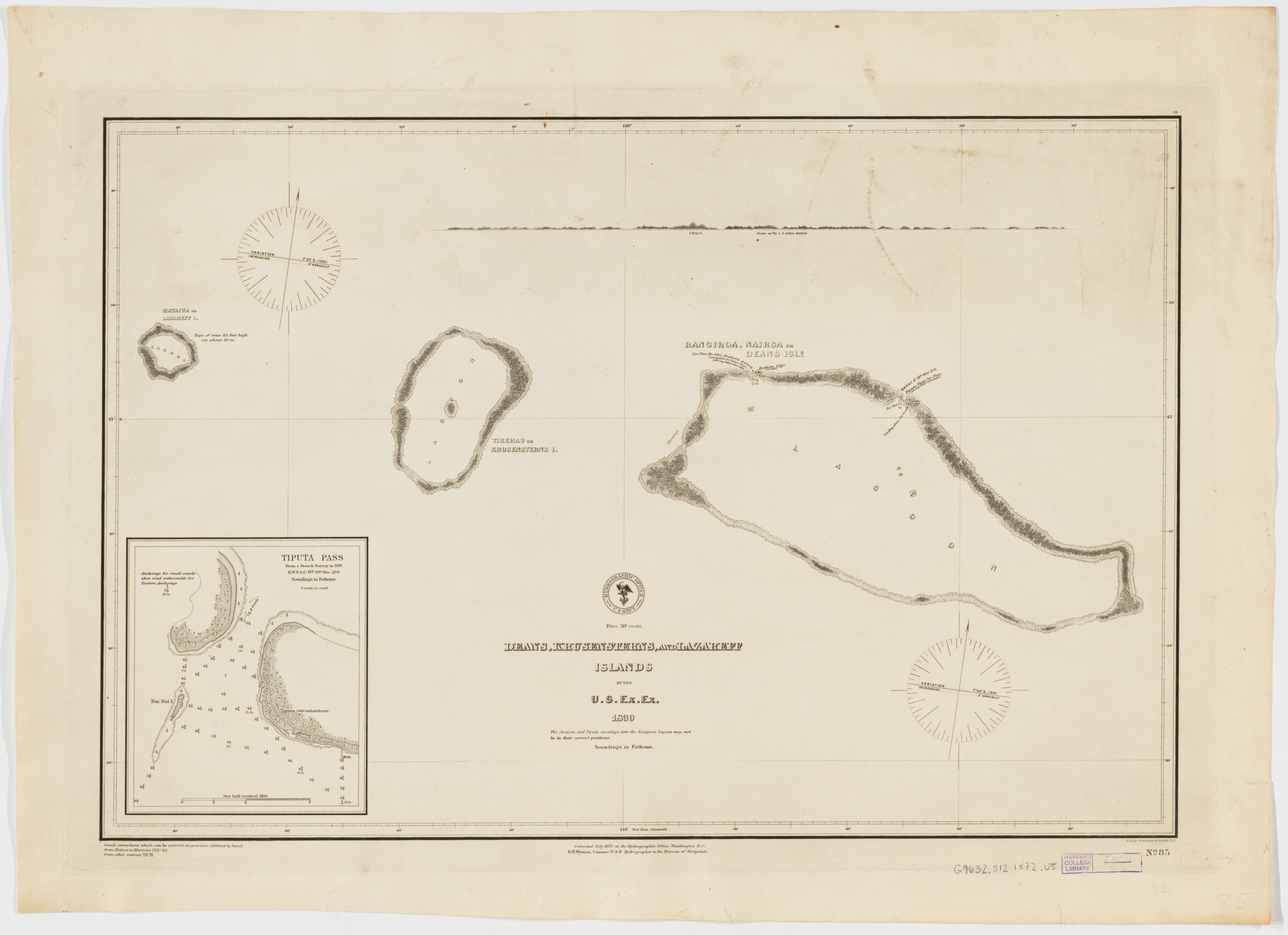
- Deans, Krusensterns, and Lazareff Islands
- United States, Hydrographic Office., creator
Wyman, R. H. (Robert Harris), 1822-1882
Sherman & Smith
United States Exploring Expedition (1838-1842) - by the U.S. Ex.Ex. ; corrected July 1872 ... R.H. Wyman, Commo. U.S.N. Hydrographer to the Bureau of Navigation.; eng. by Sherman & Smith.
- 1872
- District of Columbia
Washington, D.C - Hydrographic Office
- 1 map ; 39 x 59 cm.
- English
- map
government publication
Maps - Images
- Nautical charts--French Polynesia
Islands--French Polynesia--Maps
Îles Tuamotu-Gambier (French Polynesia)--Discovery and exploration--Maps
Rangiroa (French Polynesia)--Discovery and exploration--Maps
Tikehau (French Polynesia)--Discovery and exploration--Maps - Depths shown by soundings.
Inset : Tiputa Pass.
Includes profile of Deans.
Includes notes on corrections and sources below lower left margin.
"No. 85". - Open Collections Program at Harvard University
Harvard Map Collection digital maps - Harvard Map Collection, Harvard University
- 990115152530203941
- Title
- Deans, Krusensterns, and Lazareff Islands
- Creator / Contributor
- United States, Hydrographic Office., creator
Wyman, R. H. (Robert Harris), 1822-1882
Sherman & Smith
United States Exploring Expedition (1838-1842) - Attribution
- by the U.S. Ex.Ex. ; corrected July 1872 ... R.H. Wyman, Commo. U.S.N. Hydrographer to the Bureau of Navigation.; eng. by Sherman & Smith.
- Date
- 1872
- Place of Origin
- District of Columbia
Washington, D.C - Publisher
- Hydrographic Office
- Extent
- 1 map ; 39 x 59 cm.
- Language
- English
- Genre
- map
government publication
Maps - Digital Format
- Images
- Subjects
- Nautical charts--French Polynesia
Islands--French Polynesia--Maps
Îles Tuamotu-Gambier (French Polynesia)--Discovery and exploration--Maps
Rangiroa (French Polynesia)--Discovery and exploration--Maps
Tikehau (French Polynesia)--Discovery and exploration--Maps - Notes
- Depths shown by soundings.
Inset : Tiputa Pass.
Includes profile of Deans.
Includes notes on corrections and sources below lower left margin.
"No. 85". - Series
- Open Collections Program at Harvard University
Harvard Map Collection digital maps - Repository
- Harvard Map Collection, Harvard University
- Record ID
- 990115152530203941
Tools & Related Links
- More item details
- HOLLIS Record
Contacts
-
Joseph deVeerLibrary Project Manager and Museum LiaisonErnst Mayr Library617-495-3946
-