- Title
- [Tuamotu Group, French Polynesia]
- United States, Hydrographic Office., creator
Wyman, R. H. (Robert Harris), 1822-1882
Sherman & Smith
United States Exploring Expedition (1838-1842) - by the U.S. Ex. Ex. 1839; corrected July 1872 at the Hydrographic Office, Washington D.C.; R.H. Wyman, Commo. U.S.N. Hydrographer to the Bureau of Navigation; eng. by Sherman & Smith.
- 1887
- District of Columbia
Washington, D.C - Hydrographic Office
- Ed. of May 1887.
- 3 maps on 1 sheet ; 71 x 51 cm., each map 27 x 39 cm. or smaller.
- English
- map
government publication
Maps - Images
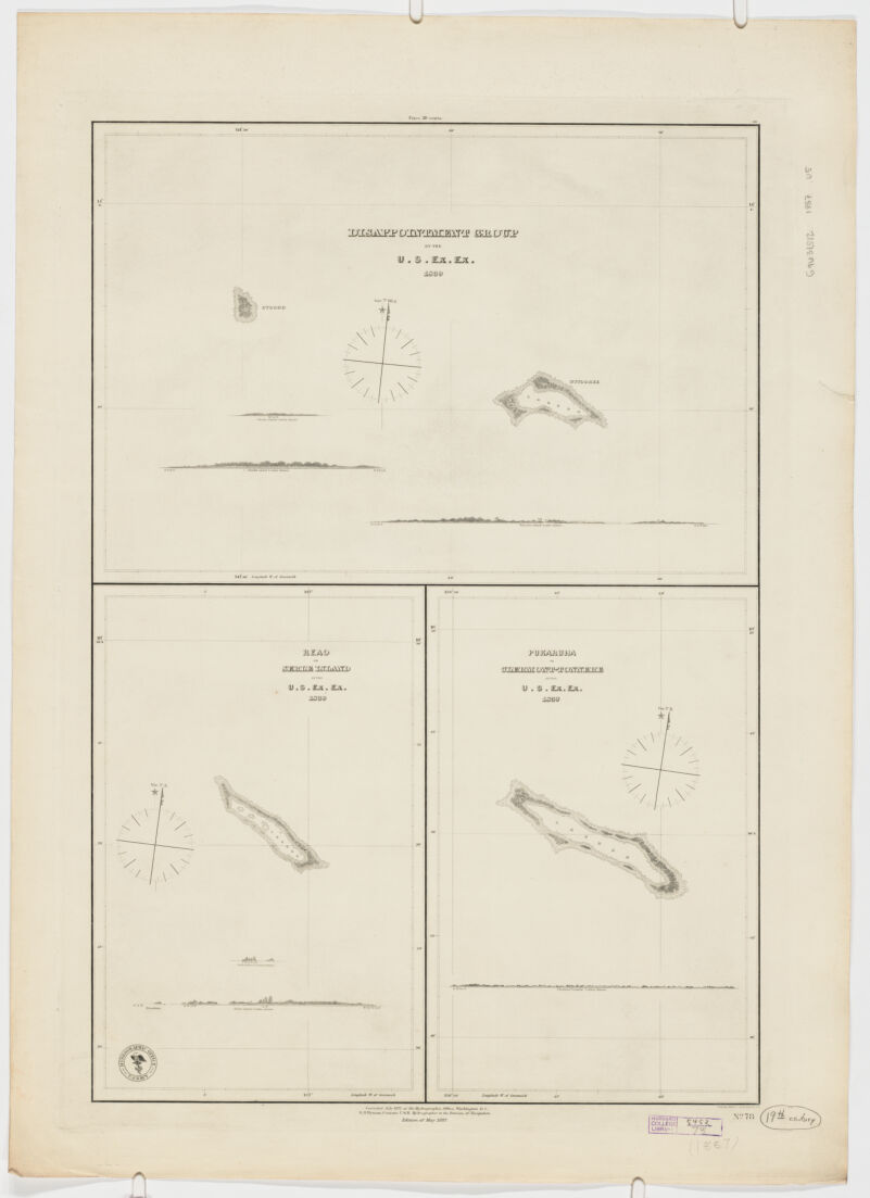
- Disappointment group includes 3 profiles of Otooho and Wytoohee Islands (Scale not given)-- Reao or Serle Island includes 2 profiles (Scale [ca.1:9,000,000]) -- Pukaruha or Clermont -Tonnere includes 1 profile (Scale [ca.1:9,000,000]).
- Discoveries in geography--19th century
Îles Tuamotu-Gambier (French Polynesia)--Discovery and exploration--Maps
French Polynesia--Discovery and exploration--Maps - Title supplied by cataloguer.
"No. 78". - Open Collections Program at Harvard University
Harvard Map Collection digital maps - Harvard Map Collection, Harvard University
- 990115152340203941
- Title
- [Tuamotu Group, French Polynesia]
- Creator / Contributor
- United States, Hydrographic Office., creator
Wyman, R. H. (Robert Harris), 1822-1882
Sherman & Smith
United States Exploring Expedition (1838-1842) - Attribution
- by the U.S. Ex. Ex. 1839; corrected July 1872 at the Hydrographic Office, Washington D.C.; R.H. Wyman, Commo. U.S.N. Hydrographer to the Bureau of Navigation; eng. by Sherman & Smith.
- Date
- 1887
- Place of Origin
- District of Columbia
Washington, D.C - Publisher
- Hydrographic Office
- Edition
- Ed. of May 1887.
- Extent
- 3 maps on 1 sheet ; 71 x 51 cm., each map 27 x 39 cm. or smaller.
- Language
- English
- Genre
- map
government publication
Maps - Digital Format
- Images
- Contents
- Disappointment group includes 3 profiles of Otooho and Wytoohee Islands (Scale not given)-- Reao or Serle Island includes 2 profiles (Scale [ca.1:9,000,000]) -- Pukaruha or Clermont -Tonnere includes 1 profile (Scale [ca.1:9,000,000]).
- Subjects
- Discoveries in geography--19th century
Îles Tuamotu-Gambier (French Polynesia)--Discovery and exploration--Maps
French Polynesia--Discovery and exploration--Maps - Notes
- Title supplied by cataloguer.
"No. 78". - Series
- Open Collections Program at Harvard University
Harvard Map Collection digital maps - Repository
- Harvard Map Collection, Harvard University
- Record ID
- 990115152340203941
Tools & Related Links
- More item details
- HOLLIS Record
Contacts
-
Joseph deVeerLibrary Project Manager and Museum LiaisonErnst Mayr Library617-495-3946
-