- Title
- [Kingsmill Group]
- United States, Hydrographic Office., creator
Wyman, R. H. (Robert Harris), 1822-1882
Sherman & Smith
United States Exploring Expedition (1838-1842) - corrected April 1873 at the Hydrographic Office Washington D.C.; R.H. Wyman Commo. U.S.N. Hydrographer to the Bureau of Navigation; eng. by Sherman & Smith, N.Y.
- 1889
- District of Columbia
Washington D. C - United States Hydrographic Office
- Ed. of Mar. 1889.
- 2 maps on 1 sheet ; 72 x 49 cm., each map 32 x 40 cm. or smaller.
- English
- map
government publication
Maps - Images
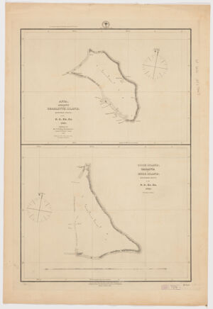
- Apia, Apaiang, or Charlotte Island, Kingsmill Group / by the U. S. Ex. Ex. 1841; additions by the U.S. Ship Narragansett, Comdr. R. W. Meade comd'g 1872. -- Cook Island, Tarawa, or Knox Island, Kingsmill Group / by the U. S. Ex. Ex. 1841.
- Nautical charts--Kiribati--Abaiang
Nautical charts--Kiribati
Tarawa (Kiribati)--Discovery and exploration--Maps
Abaiang (Kiribati)--Discovery and exploration--Maps - Title supplied by cataloguer.
Depths shown by soundings.
Prime meridian: Greenwich.
Map of Cook Island includes profile view of Tarawa.
"No. 123".
Includes notes on flora, fauna, and fish.
Electronic reproduction. Cambridge, Mass. : Harvard Geospatial Library, 2014. Georeferenced image for use in a GIS. - Open Collections Program at Harvard University
Harvard Map Collection digital maps - Harvard Map Collection, Harvard University
- 990115144680203941
- Title
- [Kingsmill Group]
- Creator / Contributor
- United States, Hydrographic Office., creator
Wyman, R. H. (Robert Harris), 1822-1882
Sherman & Smith
United States Exploring Expedition (1838-1842) - Attribution
- corrected April 1873 at the Hydrographic Office Washington D.C.; R.H. Wyman Commo. U.S.N. Hydrographer to the Bureau of Navigation; eng. by Sherman & Smith, N.Y.
- Date
- 1889
- Place of Origin
- District of Columbia
Washington D. C - Publisher
- United States Hydrographic Office
- Edition
- Ed. of Mar. 1889.
- Extent
- 2 maps on 1 sheet ; 72 x 49 cm., each map 32 x 40 cm. or smaller.
- Language
- English
- Genre
- map
government publication
Maps - Digital Format
- Images
- Contents
- Apia, Apaiang, or Charlotte Island, Kingsmill Group / by the U. S. Ex. Ex. 1841; additions by the U.S. Ship Narragansett, Comdr. R. W. Meade comd'g 1872. -- Cook Island, Tarawa, or Knox Island, Kingsmill Group / by the U. S. Ex. Ex. 1841.
- Subjects
- Nautical charts--Kiribati--Abaiang
Nautical charts--Kiribati
Tarawa (Kiribati)--Discovery and exploration--Maps
Abaiang (Kiribati)--Discovery and exploration--Maps - Notes
- Title supplied by cataloguer.
Depths shown by soundings.
Prime meridian: Greenwich.
Map of Cook Island includes profile view of Tarawa.
"No. 123".
Includes notes on flora, fauna, and fish.
Electronic reproduction. Cambridge, Mass. : Harvard Geospatial Library, 2014. Georeferenced image for use in a GIS. - Series
- Open Collections Program at Harvard University
Harvard Map Collection digital maps - Repository
- Harvard Map Collection, Harvard University
- Record ID
- 990115144680203941
Tools & Related Links
- More item details
- HOLLIS Record
Contacts
-
Joseph deVeerLibrary Project Manager and Museum LiaisonErnst Mayr Library617-495-3946
-