- Title
- [Island of Tutuila]
- United States, Hydrographic Office., creator
Wyman, R. H. (Robert Harris), 1822-1882
Boynton, George W., -1884 - R.H. Wyman Capt. U.S.N. Hydrographer to the Bureau of Navigation; eng[d] by G.W. Boynton Boston.
- [1884]
1884 - District of Columbia
Washington, D.C - Hydrographic Office
- Corrected June 1871.
- 4 maps on 1 sheet ; 58 x 40 cm., each map 29 x 19 cm.
- English
- map
government publication
Maps - Images
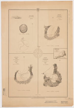
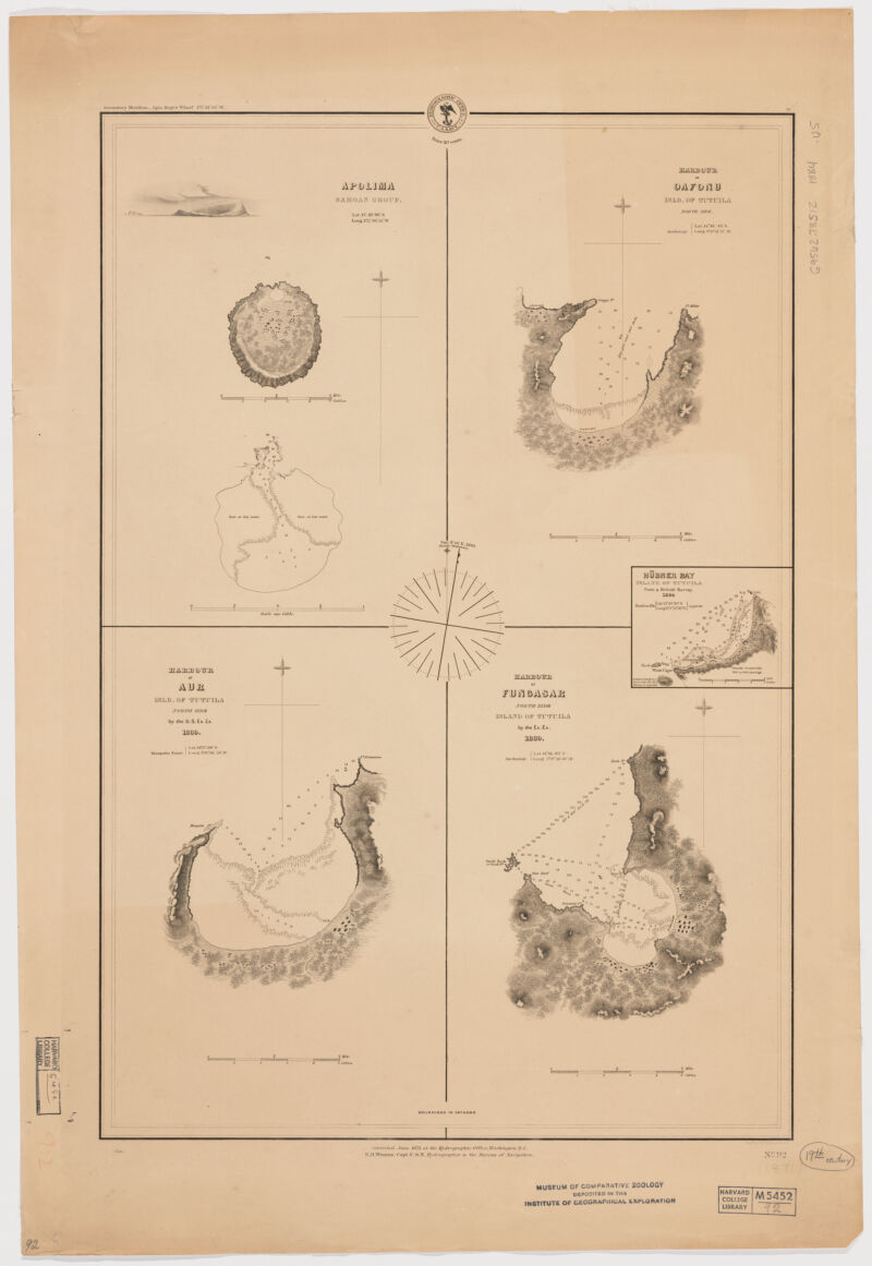
- Apolima: Samoan group -- Harbour of Oafonu: Island of Tutuil, north side -- Harbour of Aur: Island of Tutuil, north side -- Harbour of Fungasar, north side: Island of Tutuila.
- Harbors--American Samoa--Tutuila Island--Maps
Nautical charts--American Samoa--Tutuila Island
Tutuila Island (American Samoa)--Discovery and exploration--Maps - Title supplied by cataloger.
Relief shown by hachures. Depths shown by soundings.
Inset: Hubner Bay Island of Tutuila from a British Survey 1884.
Above upper left margin: "Secondary meridian - Apia, Ruge's Wharf 174°44'56'' W.
"No. 92". - Open Collections Program at Harvard University
Harvard Map Collection digital maps - Harvard Map Collection, Harvard University
- 990115128890203941
- Title
- [Island of Tutuila]
- Creator / Contributor
- United States, Hydrographic Office., creator
Wyman, R. H. (Robert Harris), 1822-1882
Boynton, George W., -1884 - Attribution
- R.H. Wyman Capt. U.S.N. Hydrographer to the Bureau of Navigation; eng[d] by G.W. Boynton Boston.
- Date
- [1884]
1884 - Place of Origin
- District of Columbia
Washington, D.C - Publisher
- Hydrographic Office
- Edition
- Corrected June 1871.
- Extent
- 4 maps on 1 sheet ; 58 x 40 cm., each map 29 x 19 cm.
- Language
- English
- Genre
- map
government publication
Maps - Digital Format
- Images
- Contents
- Apolima: Samoan group -- Harbour of Oafonu: Island of Tutuil, north side -- Harbour of Aur: Island of Tutuil, north side -- Harbour of Fungasar, north side: Island of Tutuila.
- Subjects
- Harbors--American Samoa--Tutuila Island--Maps
Nautical charts--American Samoa--Tutuila Island
Tutuila Island (American Samoa)--Discovery and exploration--Maps - Notes
- Title supplied by cataloger.
Relief shown by hachures. Depths shown by soundings.
Inset: Hubner Bay Island of Tutuila from a British Survey 1884.
Above upper left margin: "Secondary meridian - Apia, Ruge's Wharf 174°44'56'' W.
"No. 92". - Series
- Open Collections Program at Harvard University
Harvard Map Collection digital maps - Repository
- Harvard Map Collection, Harvard University
- Record ID
- 990115128890203941
Tools & Related Links
- More item details
- HOLLIS Record
Contacts
-
Joseph deVeerLibrary Project Manager and Museum LiaisonErnst Mayr Library617-495-3946
-