- Title
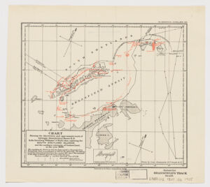
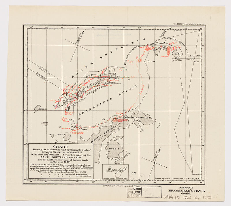
- Chart showing the discoveries and approximate track of Edward Bransfield, Master R.N. in the hired brig 'Williams' of Blyth, when exploring the South Shetland Islands and the northern extremity of Graham Land in the year 1820
- Gould, Rupert T. (Rupert Thomas), 1890-1948, creator
Bransfield, Edward. - drawn by Lieut. Commander R.T. Gould, R.N.
- 1925
- England
[London] - Royal Geographical Society
- 1 map : col ; 19 x 22 cm.
- English
- map
Maps - Images
- Discoveries in geography--19th century
Antarctica--Discovery and exploration--British--Maps
Graham Land (Antarctica)--Discovery and exploration--Maps
Bransfield Strait--Discovery and exploration--Maps
South Shetland Islands (Antarctica)--Discovery and exploration--Maps - Covers the South Shetlands and islands of Bransfield Strait as well as the coastline of Trinity Peninsula [i.e. Graham Land] and Joinville Island. The map Land relief to a limited extent is shown by spot heights and hachures.
Relief shown hachures.
Above upper right margin: The Geographic Journal, Mar, 1925.
Distinguishes by red annotations between Bransfield's own observations and soundings and features drawn from Admiralty map no. 1238.
At bottom right corner of sheet: Antarctic. Bransfield's Track. Gould.
Inset: Facsimile signature from original chart.
Includes notes.
Electronic reproduction. Cambridge, Mass. : Harvard Geospatial Library, 2014. Georeferenced image for use in a GIS. - Open Collections Program at Harvard University
Harvard Map Collection digital maps - Harvard Map Collection, Harvard University
- 990115048650203941
- Title
- Chart showing the discoveries and approximate track of Edward Bransfield, Master R.N. in the hired brig 'Williams' of Blyth, when exploring the South Shetland Islands and the northern extremity of Graham Land in the year 1820
- Creator / Contributor
- Gould, Rupert T. (Rupert Thomas), 1890-1948, creator
Bransfield, Edward. - Attribution
- drawn by Lieut. Commander R.T. Gould, R.N.
- Date
- 1925
- Place of Origin
- England
[London] - Publisher
- Royal Geographical Society
- Extent
- 1 map : col ; 19 x 22 cm.
- Language
- English
- Genre
- map
Maps - Digital Format
- Images
- Subjects
- Discoveries in geography--19th century
Antarctica--Discovery and exploration--British--Maps
Graham Land (Antarctica)--Discovery and exploration--Maps
Bransfield Strait--Discovery and exploration--Maps
South Shetland Islands (Antarctica)--Discovery and exploration--Maps - Notes
- Covers the South Shetlands and islands of Bransfield Strait as well as the coastline of Trinity Peninsula [i.e. Graham Land] and Joinville Island. The map Land relief to a limited extent is shown by spot heights and hachures.
Relief shown hachures.
Above upper right margin: The Geographic Journal, Mar, 1925.
Distinguishes by red annotations between Bransfield's own observations and soundings and features drawn from Admiralty map no. 1238.
At bottom right corner of sheet: Antarctic. Bransfield's Track. Gould.
Inset: Facsimile signature from original chart.
Includes notes.
Electronic reproduction. Cambridge, Mass. : Harvard Geospatial Library, 2014. Georeferenced image for use in a GIS. - Series
- Open Collections Program at Harvard University
Harvard Map Collection digital maps - Repository
- Harvard Map Collection, Harvard University
- Record ID
- 990115048650203941
Tools & Related Links
- More item details
- HOLLIS Record
Contacts
-
Joseph deVeerLibrary Project Manager and Museum LiaisonErnst Mayr Library617-495-3946
-